
Posts From GIS Resources

Trimble Launches Trimble Foundation
In Conjunction with International Women’s Day, Trimble Foundation Partners with Camfed to Support the Advancement of Females in Africa SUNNYVALE, Calif. March 8, 2018—Trimble (NASDAQ: TRMB) announced today that it

Big Earth Datacube Analytics Made Easy
BigDataCube project started to develop flexible and scalable services for massive spatio-temporal Earth Observation data. Project coordinator, Jacobs University Bremen, invited the joint research consortium, consisting of rasdaman GmbH (Bremen),
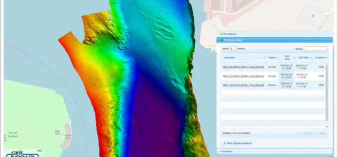
Real-time Mapping and Visualization in CARIS Onboard 2.0
Fredericton, NB, Canada – March 06, 2018 – Teledyne CARIS™ is pleased to announce the release of CARIS Onboard™ 2.0. CARIS Onboard enables users to apply processes automatically to their data in
Esri Releases Survey123 for ArcGIS with New Spike Integration
Mobile Data Capture Solution Combines Laser Measurement with Powerful Mapping Tools Redlands, California – March 6, 2018 – Esri, the global leader in spatial analytics, today announced the new software release of

FAO Launched New Tools for Reporting on World’s Forest Resources
Rome/Toluca – March 05, 2018 – FAO has launched today a new online platform for reporting on the status and trends of the world’s forest resources. The platform enables countries to increase the

Hexagon Geospatial Launches Power Portfolio 2018
March 01, 2018 – Hexagon Geospatial announces the official release of Power Portfolio 2018. The Power Portfolio helps a wide range of customers Shape Smart Change by providing solutions that harness
115th Congressional Districts with 2010 Census Data and 2016 ACS Data for Use with Maptitude
NEWTON, MASSACHUSETTS (USA) – March 6, 2018 – Caliper is excited to announce that the 2018 edition of Congressional Districts data is now available for the entire USA. These are the most
Mapbox Launches Global Reality-Grade AR Location Platform
BARCELONA, Spain, Feb. 26, 2018 /PRNewswire/ — As static 2D maps fade away with the bezels of mobile phones, the future interfaces for navigation and gaming exist in augmented reality. App developers need

OGC Seeks Public Comment on Web Services Security Candidate Standard
Security Standard allows the hosting of OGC Web Services (OWS) over HTTPS as well as the implementation of Information Assurance March 1, 2018 – The Open Geospatial Consortium (OGC) seeks

TatukGIS Releases GIS SDK for Java
Gdynia, Poland – TatukGIS now brings its nearly two decades of GIS technology expertise to the Java development platform. The new Developer Kernel for Java edition is a general-purpose GIS SDK
