
Posts From GIS Resources
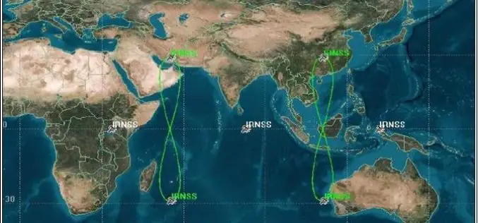
Indian Satellite Navigation Policy (SATNAV Policy) – 2021 to Achieve Self-Reliance in Satellite-Based Navigation and Augmentation Services
Department of Space being the administrative Ministry/Department in respect of space activities in India has released a draft of “Indian Satellite Navigation Policy (SATNAV Policy) -2021.” The policy has been
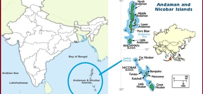
India Plans for Airborne Radar Survey of Andaman and Nicobar Islands
Speaking in Lok Sabha, Jitendra Singh Minister of State (independent charge) for Science and Technology and Earth Sciences Ministry said that the Government of India is planning to conduct an

3D Sensors: The Nifty Technology to Develop as a Smarter Investment for Future
About Author Abhinav Chandrayan has worked in the Writing industry for 2 years, gaining experience in Media & Advertising and Market Research Industry. As a seasoned writer, he is passionate

How to Protect Yourself against Location Tracking?
Turning off the location services of your smartphone or laptop doesn’t change much. At best, it helps you save some precious battery. Right? Nowadays, due to the nature of wireless

Hedge Funds Guide on Gold, Silver, and Bitcoin for a Retirement Plan
As we grow older, we start to understand several aspects of society that, back when we were kids or teenagers, didn’t make as much sense. One of those things becomes

NAVAID Calibration Drone by Cursir Helped to Speed Up the Flight Check of the Landing System of the Ulyanovsk Airport
Last year, by order of the Federal Air Transport Agency of Russia, a working group was created on the implementation of UAVs to calibrate, check and configure navigation aids at

Mobile App to Boost the Cardamom Growth and Help Farmers with Site-specific Recommendations
According to recent news by The Hindu, the Spices Board and Rubber Board has signed a memorandum of understanding (MoU) with the Digital University of Kerala. The MoU was signed

Pix4D Announces Entering Into An Exclusive Reseller Partnership With Beijing Skymap Technology Co., Ltd. For Mainland China
Pix4D, the photogrammetry industry leader, today announced the signing of an exclusive reseller partnership with Beijing Skymap Technology Co., Ltd. a high-tech enterprise integrating software sales, service, research and development,

Trimble Boosts Flagship RTX Correction Services Performance – Continuing to Raise the Bar for Geospatial Users
Cutting GNSS Signal Convergence Means Significant Time Savings for Surveyors Trimble (NASDAQ: TRMB) has announced enhancements to its industry-leading Trimble RTX® correction services, tailored to meet the evolving needs of geospatial

Forest Cover Monitoring In Urban Agglomeration Using Google Earth Satellite Image – A Case of Bhubaneswar City, Odisha
Combining several remote sensing technologies to estimate forest
cover attributes will greatly improve resource assessment.
