Supergeo Technologies, the leading GIS software and solution provider, announces that SuperGIS Desktop assists Mesurage Group Pty Ltd, Australia to process surveyed data for value-added applications and services.
Located in Victoria, Australia, Mesurage Group has provided flexible and high quality surveying and mapping services for decades. With SuperGIS Desktop, the firm is able to save and transform surveyed data into common-use forms, so that the data can be shared and for value-added applications.

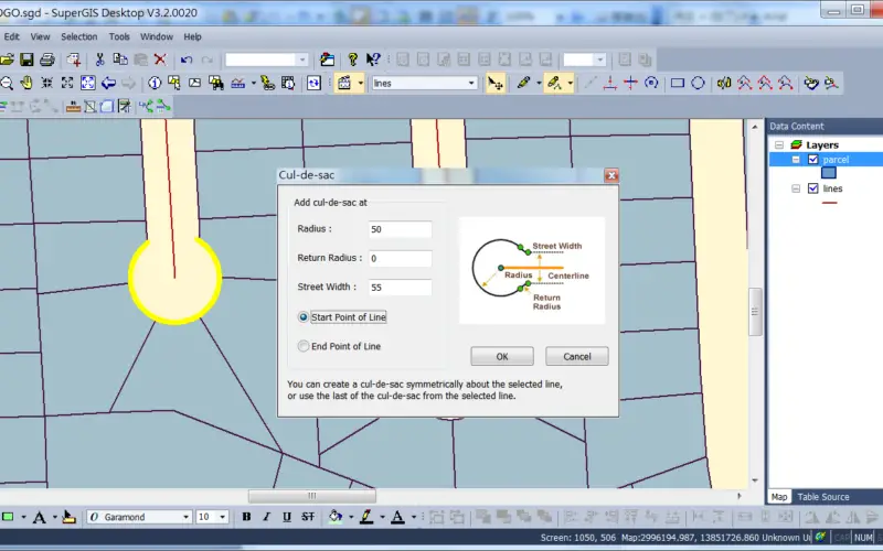
With convenient editing functions, users are capable to digitize collected data with ease. Also, COGO,coordinate geometry tool, is built in for advanced needs, like Ground to Grid Conversion is designed to minimize errors between real world and digitized maps.
Through hardware partner FOIF, professional survey equipment provider, worldwide users are able to select complete turnkey solution for their projects. Besidepowerful desktop solution, Supergeo also offers GIS for server and mobile to integrate huge map data on different platforms for various applications.
Get free trial to add values of your survey projects
http://www.supergeotek.com/download_6_desktop.aspx
Learn more about SuperGIS Desktop Add-Ons, COGO & Parcel Editor
https://www.youtube.com/watch?v=L8t5WHzcKiY
# # #
About Supergeo
Supergeo Technologies Inc. is a leading global provider of GIS software and solutions. Since the establishment, Supergeo has been dedicated to providing state-of-the-art geospatial technologies and comprehensive services for customers around the world. It is our vision to help users utilize geospatial technologies to create a better world.
Supergeo software and applications have been spread over the world to be the backbone of the world’s mapping and spatial analysis. Supergeo is the professional GIS vendor, providing GIS-related users with complete GIS solutions for desktop, mobile, server, and Internet platforms.