
Archive

Pix4D Announces Entering Into An Exclusive Reseller Partnership With Beijing Skymap Technology Co., Ltd. For Mainland China
Pix4D, the photogrammetry industry leader, today announced the signing of an exclusive reseller partnership with Beijing Skymap Technology Co., Ltd. a high-tech enterprise integrating software sales, service, research and development,

Trimble Boosts Flagship RTX Correction Services Performance – Continuing to Raise the Bar for Geospatial Users
Cutting GNSS Signal Convergence Means Significant Time Savings for Surveyors Trimble (NASDAQ: TRMB) has announced enhancements to its industry-leading Trimble RTX® correction services, tailored to meet the evolving needs of geospatial

Forest Cover Monitoring In Urban Agglomeration Using Google Earth Satellite Image – A Case of Bhubaneswar City, Odisha
Combining several remote sensing technologies to estimate forest
cover attributes will greatly improve resource assessment.
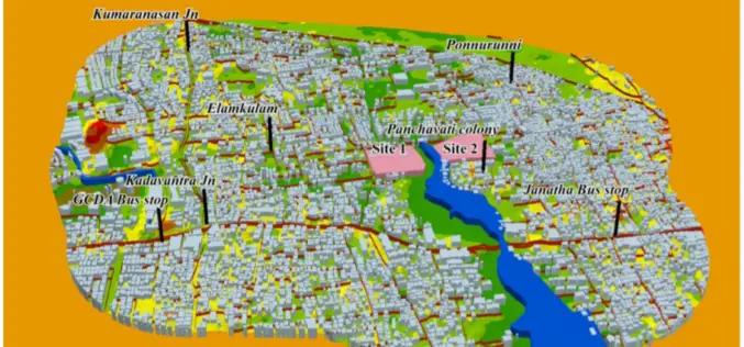
GIS-based System for Optimal Site Selection of Sewage Treatment Plants
Kerala Water Authority (KWA) has come-up with a new tool using Geographical Information System (GIS) for optimal site selection of Sewage Treatment Plants (STP). A GIS is a system designed

Greater Noida Launches Citizen-Centric GIS Mobile App – GNIDA GIS
Greater Noida becomes the first Smart City in Nation Capital Region (NCR) to launch a citizen-centric GIS Mobile App. Citizens of the Greater Noida city can get information of plots

Trimble MX50 LiDAR System Expands Mobile Mapping Portfolio
Vehicle-Mounted System Enables Data Capture for Road Agencies and Local Governments Trimble has introduced the Trimble® MX50 mobile mapping system for asset management and mapping—a new addition to its established

Euclideon Plans World’s Largest Geospatial Data Platform on Microsoft Azure, Accelerates Innovation Opportunity
Cloud based service visualises a petabyte of data per second Leading 3D data specialist Euclideon has signed a strategic partnership with Microsoft and unveiled plans to build the world’s largest geospatial data

Why Are More People Hiring Virtual Assistant Nowadays? Your Top Questions Answered
If you have always been pressed for time and can’t seem to fit all your pending tasks and responsibilities into the standard 24 hours, you’re not alone. A good percentage
