
Archive

Work Easier with Satellite Images – LandViewer Launches New Features
MENLO PARK, Calif. – The California-based company EOS have launched cloud based tool LandViewer, that allows non-expert users to select a geographic area for analysis, an earth observation data types,

Advanced Artificially Intelligent Unmanned Aerial System (UAS) With Microsoft Researchers
Hawthorne, N.V. (August 10, 2017) – The Nevada Governor’s Office of Economic Development (GOED) and the Nevada Institute for Autonomous Systems (NIAS) has teamed up with Microsoft’s Unmanned Aerial System (UAS)

Malaysian Geospatial Master Plan to be Completed in 2018
August 22, 2017 – Putrajaya, Malaysia: The Natural Resources and Environment Ministry (NRE) is developing the National Geospatial Master Plan (NGMP) towards realising the potential of geospatial technology, in line with the

South Dakota State University Ranks 27th in World for Remote Sensing Research
AUGUST 21, 2017 – South Dakota State University was ranked 27th worldwide and 7th in the United States for research productivity in the area of remote sensing, according to ShanghaiRanking’s 2017

Telangana: Land Registry of all ULBs Completed
August 23, 2017 – According to recent news by The Indian Express, the Integrated Urban Land Registry (IULR) for 72 Urban Local Bodies (ULBs) (other than GHMC) will soon be uploaded
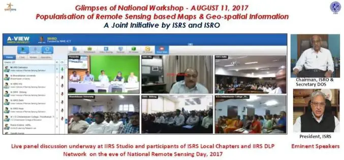
National Workshop on Popularisation of Remote Sensing Based Maps and Geo-spatial Information
August 22, 2017 – A National Workshop on Popularisation of Remote Sensing Based Maps and Geo-spatial Information was organised jointly by ISRS and ISRO on the eve of National Remote Sensing
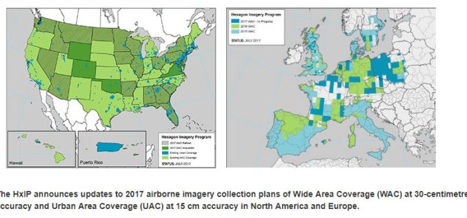
Hexagon Imagery Program Announces Updates to 2017 Airborne Imagery Collection Plans
Latest imagery collection covers U.S., Canada, Europe, plans include territories, cities (WASHINGTON, D.C., Aug. 15, 2017) – The Hexagon Imagery Program (HxIP), the premier source for professional airborne imagery provided
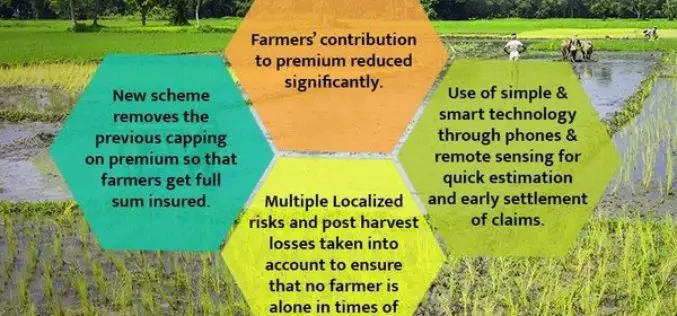
PM Modi Reviews Progress of Soil Health Cards and Pradhan Mantri Fasal Bima Yojana
In the Kharif season of 2016 and Rabi season of 2016-17, claims of over Rs. 7700 crores paid PMFBY: Over 90 lakh farmers benefitted August 21, 2017 – India, The

ARSET NASA Webinar: Introduction to Remote Sensing of Harmful Algal Blooms
Webinar: Introduction to Remote Sensing of Harmful Algal Blooms Dates: Tuesday, September 5, 2017 to Tuesday, September 26, 2017 Times: 11:00–12:00 and 21:00–22:00 EDT (UTC-4) Harmful algal blooms (HABs) can have a negative

Japan Successfully Launches 3rd Satellite of Quasi-Zenith Satellite System
August 19, 2017 – Mitsubishi Heavy Industries, Ltd. and JAXA successfully launched H-IIA Launch Vehicle No. 35 (H-IIA F35) which encapsulates MICHIBIKI No. 3, (Quasi-Zenith Satellite System; geostationary orbit) at 2:29:00
