
Archive

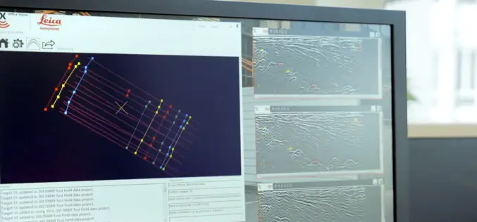
Leica Cyclone REGISTER 360, Cloud Services offer speed, scale and simplicity to the digital reality capture market
15 JUNE 2017 – Hexagon, a leading global provider of information technology solutions, announced today its new Leica Cyclone REGISTER 360 laser scanning software for simpler, automated registration, and its Cyclone

A Smart City for Its Inhabitants with Sustainable Growth
The term “smart city” has become a familiar word during the past year or two. But as yet few really know what it envisages, how it is to

SI Imaging Services Signs MoU with Luciad NV in Belgiumand G-Ros in Korea
On June 14th at the Grand Hyatte Seoul, the SI Imaging Services has signed a Memorandum of Understanding (MoU) with the Luciad NV in Belgium and its certified reseller in

Leica Geosystems Introduces Imagery, Live Video Stream to Monitoring
Leica GeoMoS Imaging increases productivity, reduces time in the field (Heerbrugg, Switzerland, 13 June 2017) – Leica Geosystems, industry leader in measurement technology, announced today Leica GeoMoS Imaging, a monitoring
New Utility Post Processing Software Delivers CAD Drawings in Less Time with Professional Results
Leica DX Office Vision enables non-experienced CAD users to digitally map detected underground utilities (Heerbrugg, Switzerland, 14 June 2017) – Leica Geosystems, industry leader in measurement technology, released today its

NASA ARSET Training: Introduction to Synthetic Aperture Radar
NASA ARSET Training: Introduction to Synthetic Aperture Radar Dates: Wednesday, June 28, 2017 to Thursday, July 6, 2017 Times: 12:00-1:00 p.m. and 9:00-10:00 p.m. EDT (UTC-4) Introduction: A limitation of optical satellite remote
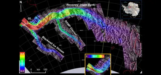
Excellence in space – 10 years of TerraSAR-X
The TerraSAR-X satellite has been in service for twice the planned time. The data has been providing valuable insights regarding changes to the Earth’s surface for the past 10 years.
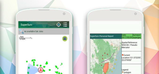
New Features of SuperSurv 10 that You Cannot Ignore
The global IT industry is skyrocketing today, and so does the development of geospatial industry, especially the progress of integrating GIS and GNSS technologies into mobile devices. Base on such

Ministry of Public Works of Indonesia Selects SuperSurv
With the assistance of Supergeo’s reseller in Indonesia- GPS Lands Indosolutions, the Ministry of Public Works and Housing (Kementerian PUPR) of Indonesia has selected SuperSurv for their tasks of spatial
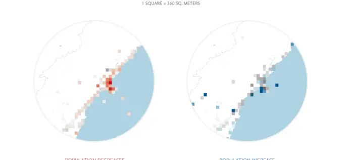
Facebook Launches Disaster Maps to Help Communities Recover and Rebuild
According to recent news by the Facebook Newsroom, Facebook is introducing disaster maps that use aggregated, de-identified Facebook data to help organizations address the critical gap in the information they often
