
Archive

Geotagging of Pipelines for Effective Water Supply Management
Hyderabad-India: According to recent news by The New Indian Express, the Hyderabad Metro Water Supply and Sewerage Board (HMWS&SB) has drawn plans to prepare a reliable and accurate GIS map

PCI Geomatics Announces Collaboration with Deimos Imaging to Support the PanGeo Alliance
MARKHAM, Ontario, Canada—January 10, 2017: PCI Geomatics, a world-leading developer of remote sensing and photogrammetric software and systems, announced today it will be collaborating closely with Deimos Imaging to support
Esri Shares a Vision for the Connected Car at CES 2017
Experience the Future of Connected Driving at CES with Microsoft, Esri, NXP, IAV, Cubic Telecom, and Swiss Re Redlands, California—Esri, the global leader in spatial analytics technology, announced its participation

BARSC Welcomes the Satellite Applications Catapult as New Member
The British Association of Remote Sensing Companies is delighted to announce that the Satellite Applications Catapult has taken advantage of the new Observer Membership class and joined the Association. From
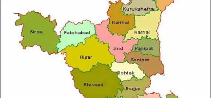
HARSAC Uses Drones to Create “Most Accurate Maps” of Gurugram for Land Records Management
New Delhi : Haryana State Remote Sensing Application Centre (HARSAC) and local administration made optimum use of the technology at their disposal as they used 24 satellites and drones to

Timmons Group Webinar | Squashing Zika with GIS!
Squashing Zika with GIS! Thursday, January 26th | 2 – 3 pm EST Timmons Group is a leading provider of geospatial information architecture and engineering services throughout the United States and
Woolpert Contracted to Collect Orthoimagery for Ohio
COLUMBUS, Ohio (Jan. 4, 2017) — Woolpert has been contracted to acquire high-resolution orthoimagery for the entire state of Ohio, which is roughly 41,276 square miles, by the Ohio Geographically
Cumberland County Launches New Property Mapper Application
Cumberland County, PA, January 3, 2017- At their public meeting today, the Cumberland County Board of Commissioners announced the release of a new online property mapper application now available to

Avenza MAPublisher Now Features ArcGIS Online Integration within Adobe Illustrator
Connect to ArcGIS Online within Adobe Illustrator to import and work with data layers Toronto, ON, January 4, 2017 – Avenza Systems Inc., producers of the Avenza Maps app for
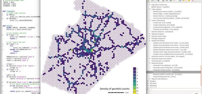
GRASS GIS 7.2.0 Released
After almost two years of development the new stable major release GRASS GIS 7.2.0 is available. It provides more than 1950 stability fixes and manual improvements compared to the former
