
Archive

Reading the ABCs from Space
Contributed By:- Space and space-based technologies offer significant and unique solutions to many of real-world problems through remote monitoring and accessing information. Revolution in Earth observations from space has fueled by
Boundless Launches GIS Products Based on Open-Source, Data-Rich Future
Boundless is betting that open source, non-proprietary and license-free is the future of the geographic information systems (GIS) market. It’s a bet wagered in the form of dual product launches this

OGC Seeks Public Comment on a Proposed Work Item for Indexed 3D Scene Layers as a Community Standard Work Item
The Open Geospatial Consortium (OGC®) is considering start of a new work item for a Community Standard: Indexed 3D Scene Layers (I3S). The public is requested to comment on this
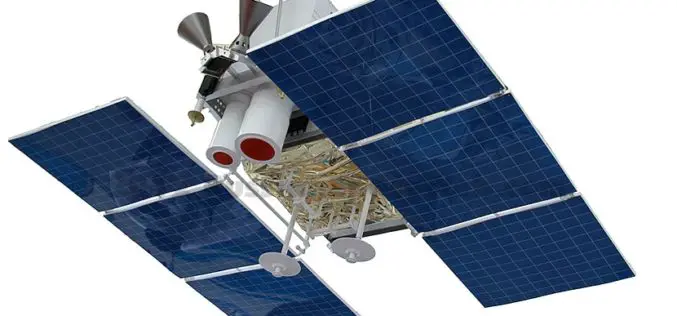
Russian Satellite “Canopus” Will be Part of Joint BRICS Nations
According to recent news Russia & India Report, the Russian satellite ‘Canopus’ will be part of the BRICS countries (Brazil, Russia, India, China and South Africa) joint grouping of remote sensing
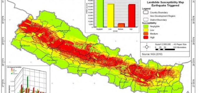
Nepal: Pilot Project on Landslide Hazard Mapping
Kathmandu – According to recent news by The Himalayan Times, the Department of Soil Conservation and Watershed Management, Nepal has started a pilot project of landslide hazard mapping from Dolakha

“UNMANNED WORLD”, the first and most complete Exhibition of Unmanned Vehicles in Middle East will take place at Qatar in April 2017
Unmanned World will gather Robotics and Unmanned ground and surface vehicles (UGV & USV), Remotely Operated Vehicles (ROV) and Unmanned Aerial Vehicles UAV, which are one of the largest investment opportunities worldwide. Unmanned

Bhubaneswar Municipal Corporation to Map Hoardings to Increase Revenue
BHUBANESWAR, Odisha – According to recent news reported by The Time of India, the Bhubaneswar Municipal Corporation (BMC) has decided to bring the locations of all the advertisements or hoardings

Trimble Geospatial Webinar: The Ultimate Integration of Scan Data into Everyday Survey Workflows with the Trimble SX10 Scanning Total Station
The Ultimate Integration of Scan Data into Everyday Survey Workflows with the Trimble SX10 Scanning Total Station November 16, 2016 | 8 AM MDT and 4 PM MDT This session
Live Webinar on Projections Hosted by Blue Marble Geographics
Deep Dive into projections with Blue Marble’s Sam Knight and special guest, Dave Doyle, former Chief Geodetic Surveyor at the National Geodetic Survey December 7, 2016 at 2:00 pm EST

ESA and SAP Launch New Service For Analysing Satellite Data
ESA and the software company SAP have announced the Earth Observation Analysis service for the quick, easy consumption of Earth observation satellite data according to customer needs. Powered by SAP’s
