
Archive

DLR and CNES Sign an Agreement for the Construction and Operation of the MERLIN Environmental Satellite
On 14 September 2016 in Berlin, the German Aerospace Center (Deutsches Zentrum für Luft- und Raumfahrt; DLR) and the French space agency (Centre national d’études spatiales; CNES) signed a cooperation
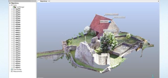
FARO Releases SCENE Version 6.1, Introducing a Fully Integrated Point Cloud to 3D Mesh Engine for Product Design and Construction BIM-CIM Professionals
Lake Mary, FL, September 6, 2016, 2016 – FARO (NASDAQ:FARO), the world’s most trusted source for 3D measurement and imaging solutions for factory metrology, product design, construction BIM/CIM, public safety

Drones to Monitor Indian Railways Projects
PTI- NEW DELHI: Stepping up the monitoring mechanism, railways has opted for the state of the art surveillance devices such as drone and geo-based spatial based satellite technology to monitor

Velodyne LiDAR Announces Puck Hi-Res LiDAR Sensor
Velodyne LiDAR Announces Puck Hi-Res LiDAR Sensor, Offering Higher Resolution to Identify Objects at Greater Distances Expanding on Velodyne LiDAR’s groundbreaking VLP-16 Puck, a 16-channel, real-time 3D LiDAR sensor that weighs
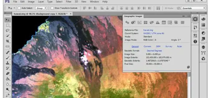
Avenza Releases Geographic Imager 5.1 for Adobe Photoshop
GeoPackage now a supported format Toronto, ON, September 13, 2016 – Avenza Systems Inc., producers of the Avenza Maps app for mobile devices and geospatial plug-ins for Adobe Creative Cloud,

Topcon Announces Enhancements to UAS Packages
LIVERMORE, Calif., USA/ CAPELLE A/D IJSSEL, The Netherlands – September 13, 2016 – Topcon Positioning Group announces the release of two new mapping kits for its Sirius Pro fixed-wing unmanned

Esri Webinar: Transform Conservation with Drone2Map for ArcGIS
Conservationists are being called on to do more with less. In the face of climate change, widespread pollution, and urbanization, conservation has become paramount to the health and well-being of
Shelby County, Indiana to Get New Mapping System
According to recent news reported by The Shelbyville News, Shelby County’s GIS board of directors has given up a positive node to the purchase of the new LIDAR mapping database. All
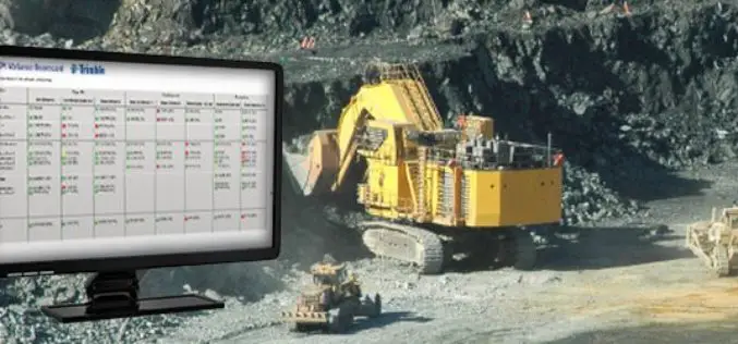
Trimble Connected Mine Provides Spatial Data Visualization Using Trimble and Microsoft Mixed-Reality Technologies
Trimble Provides a Single Source of Data Across the Mine Enterprise SUNNYVALE, Calif., Sept. 13, 2016—Trimble (NASDAQ:TRMB) announced today the release of its Trimble® Connected Mine™ Visual Intelligence module with

Hyderabad Metropolitan Development Authority Plan to Integrate Previous Five Master plans
Hyderabad, India – According to recent news reported by The Hindu, Hyderabad Metropolitan Development Authority (HMDA) is planning to integrate previous five master plans into a single Metropolitan Development Plan (MDP)
