
Archive
Esri’s Federal Small Business Program Grows at Rapid Pace
Over 50 Small Business Partners Become Members of Specialty Redlands, California—Since the inception of the Esri Federal Small Business Specialty in February, Esri has garnered participation from over 50 industry
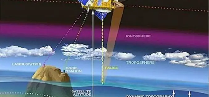
Webinar: NASA Space Geodesy Data for Precise Orbit Determination of Altimeter Satellites
Webinar: NASA Space Geodesy Data for Precise Orbit Determination of Altimeter Satellites Wednesday, June 29, 2016 at 2:00PM EDT (UTC/GMT-4) Over the last 25 years, ocean radar altimeter satellites have

Build Smart 3D Cities in Minutes with Game-Changing Esri CityEngine 2016
Redlands, California—Esri, the global leader in geographic information system (GIS) solutions, today announced the release of Esri CityEngine 2016. This revolutionary modeling technology allows GIS professionals, 3D artists, architects, and

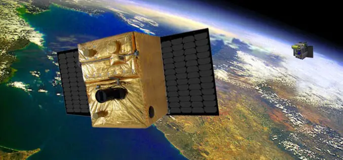
Great Day in Indian Space History With the Launch of 20 Satellites in a Single Mission
In its thirty sixth flight (PSLV-C34), ISRO’s Polar Satellite Launch Vehicle successfully launched the 727.5 kg Cartosat-2 Series Satellite along with 19 co-passenger satellites on June 22, 2016 from Satish

London Mapped in Original OS Style
21 June 2016 – Today Ordnance Survey (OS) is mining data used daily at all levels of national and local government, by the emergency services and large and small businesses. That data
BIROS Fire Detection Satellite Successfully Launched into Space
On 22 June 2016 at 05:55 CEST, the BIROS (Bi-Spectral Infrared Optical System) microsatellite was successfully launched into space from the Satish Dhawan Space Centre in India on board a Polar

Abu Dhabi Municipality Launches GIS Platform for Submittal of Road Layout Data
In a major boost and expansion to the e-services, The Abu Dhabi City Municipality (ADM) has launched a platform that allows submittal of roads layout data standards using Geographic Information
Iranian Space Agency to Put Indigenous Satellite in Orbit by 2025
According to recent news by MNA – ISA deputy director has announced Iran’s ultimate goal as building indigenous satellites parallel to foreign models and to place them into geosynchronous equatorial

Cornerstone Mapping Processing Thermal Imagery with SimActive
SimActive Inc., a world-leading developer of photogrammetry software, is pleased to announce purchase of Correlator3D™ by Cornerstone Mapping Inc. Based in the U.S., they are primarily using the software to
Post-Doctoral Researcher in Grass Crop Remote Sensing and Modelling
The University of Reading is ranked in the top 1% of universities in the world. We are a global university that enjoys a world-class reputation for teaching, research and enterprise.
