The U.S. Geological Survey has announced the first recipients of the 2016 partnership funding awards for the 3D Elevation Program. This program, referred to as 3DEP, presents a unique opportunity for collaboration between the USGS and other federal, state and local agencies to leverage the services and expertise of private sector mapping firms that acquire high-quality, three-dimensional mapping data of the United States.
“We are very excited about the growing interest in our 3DEP initiative across all levels of government. I’m particularly pleased with the outstanding quality of the project proposals we received for this award opportunity,” said Kevin Gallagher, USGS Associate Director for Core Science Systems.
Thus far in 2016, partnership funding has been awarded to 21 proposals in 19 states and territories. The total data acquisition for FY16 is expected to result in the influx of more than 150,000 square miles of public domain lidar point cloud data and derived elevation products into the 3DEP program.
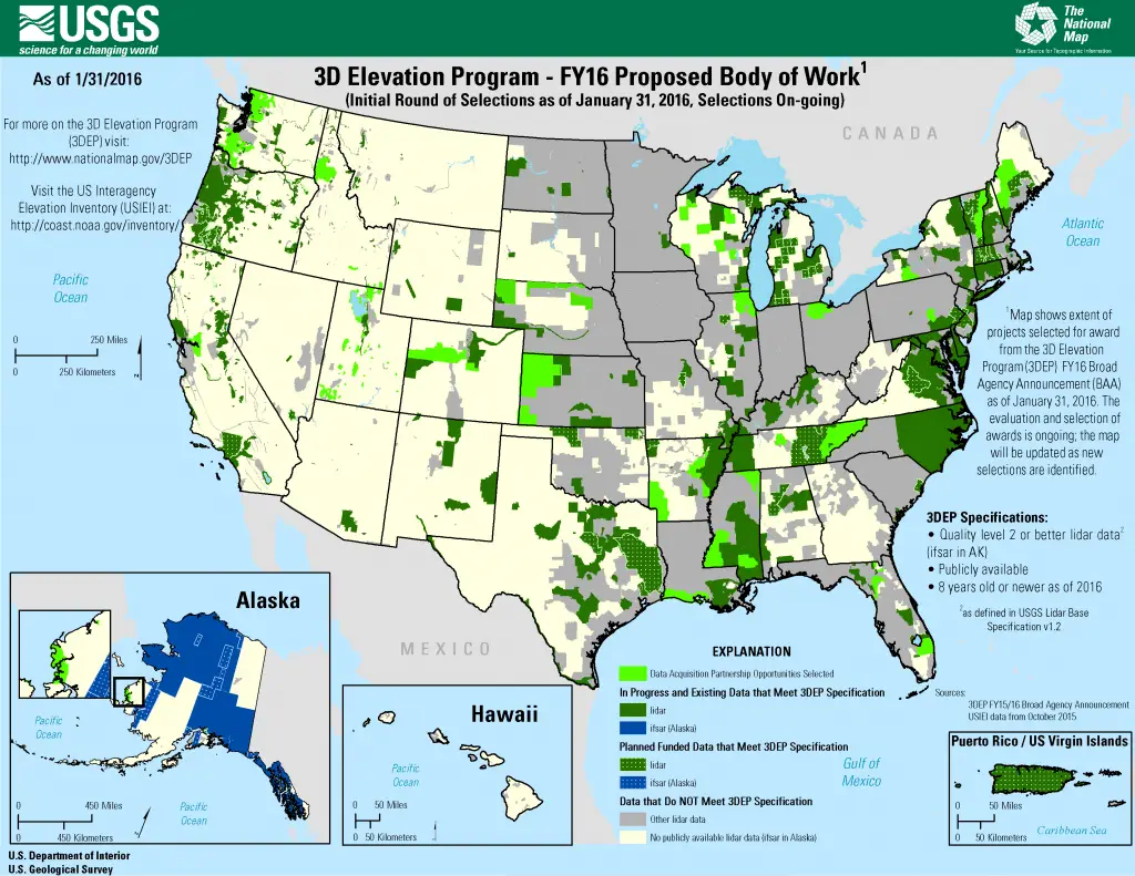
Map depicts the status of BAA awards to date. Project selection is ongoing and will be posted at the 3DEP website. The FY16 3DEP data acquisition is projected to add more than 150,000 square miles of 3DEP quality lidar data to the national database.
These 2016 awards are the result of a Broad Agency Announcement (BAA) for the 3D Elevation Program, issued on July 17, 2015. (Fed Biz Opps G15PS00558 and Grants.gov G15AS00123). The BAA is a publicly accessible process to develop partnerships for the collection of lidar and derived elevation data for 3DEP.
The primary goal of 3DEP is to systematically collect nationwide lidar data, with IfSAR data in Alaska, over an 8-year period. 3DEP is designed based on an extensive benefit-cost analysis to conservatively provide new benefits of $690 million/year with the potential to generate $13 billion/year in new benefits through applications that span the economy.
Lidar, short for light detection and ranging, is a remote sensing detection system that works on the principle of radar, but uses light from a laser. Similarly, IfSAR, short for interferometric synthetic aperture radar is used to collect data over Alaska due to cloud cover, extreme weather conditions, rugged terrain and remote locations.
Current and accurate 3D elevation data are essential to help communities cope with natural hazards and disasters such as floods and landslides, support infrastructure, ensure agricultural success, strengthen environmental decision-making and bolster national security.
Federal funds to support this opportunity were provided by the USGS, the Federal Emergency Management Agency and the Natural Resources Conservation Service. The USGS is acting in a management role to facilitate planning and acquisition for the broader community, through the use of government contracts and partnership agreements.
More information about 3DEP including updates on current and future 3DEP partnership opportunities is available online.