
Archive
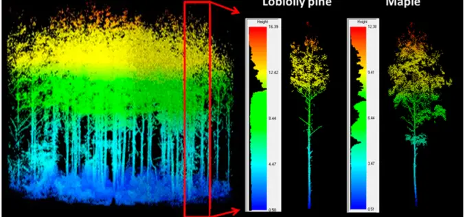
LiDAR Scanning Can Help Identify Structurally Heterogeneous Forest Areas
The inequality of tree sizes in a forest is an important factor affecting its structure and ecology. Forest management practices favouring natural regeneration can result in greater heterogeneity and complexity

Indian Student Bags Germany’s Green Talents Award
Arun Prasad Kumar, a Ph.D. scholar from Indian Institute of Space Science and Technology (IIST) has bag a Germany ‘Green Talents Award’ at the 7th Green Talents 2015. He is the

GAIL to Use Drones, Satellite Mapping To Monitor Pipeline Network
GAIL (India) Ltd has decided to use drones and satellite imagery to map and monitor its pipeline network while expanding its Sahyogi (partner) scheme to detect/prevent encroachment and terror attack

ViviSat Remote Sensing License Approved
BELTSVILLE, Md.–(BUSINESS WIRE)–ViviSat LLC announced today that the Commercial Remote Sensing Regulatory Affairs Office of the National Oceanic and Atmospheric Administration, an agency of the Department of Commerce, has granted

ESA Issues Call For New Earth Explorer Proposals
ESA is announcing an opportunity for scientists involved in Earth observation to submit proposals for the next potential Earth Explorer satellite mission. Traditionally, Earth Explorers use new measurement techniques to
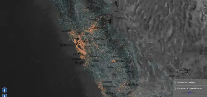
Mapping Tool to Map Impact of Non-compliant Volkswagen Cars
Based on the ICCT report, EPA has started an investigation into Volkswagen’s “clean diesel” vehicle fleet. It has been found that Volkswagen installed “defeat devices” to enable the cars to
Transform Your Flood Preparedness with ArcGIS
Transform Your Flood Preparedness with ArcGIS Wed, Dec 9, 2015 10:30 PM – 11:30 PM IST Time is running out to prepare for historic weather events fueled by El Niño.

UAS Task Force Outlines Recommendations for Registration
The Federal Aviation Administration released the initial Task Force recommendations for the registration of small unmanned aerial systems (UAS). In October, PrecisionHawk was selected by the Department of Transportation to

Flipkart to Buying Stake in MapmyIndia
According to recent news by Livemint, online marketplace Flipkart Ltd is in talks to invest in four firms including maps provider MapmyIndia, to improve its supply chain efficiency. The Bengaluru-based

Google Maps Now Available Offline in India
Almost a week after announcing it in the US, last week Google has brought its Google Maps offline service to India. Google’s offline map makes the popular navigation and mapping tool
