
Archive

Trimble Partners with Industry Leading Multirotor Unmanned Aircraft System Manufacturer
New Geospatial and Agriculture Workflows and Deliverables through Additional Aerial Imaging Solutions ATLANTA, May 5, 2015—Trimble (NASDAQ: TRMB) announced today that it is partnering with leading unmanned aircraft system (UAS)
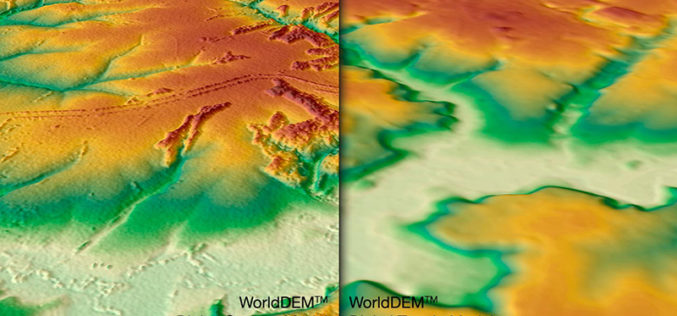
WorldDEM DTM Now Available
Precise Terrain Information Globally for Effective Analysis The WorldDEM Digital Terrain Model (DTM) is now commercially available for all users that need superior terrain information anywhere on the globe. The
International Training Course On “Ocean Colour Remote Sensing – Data, Processing and Applications” Organized by ITCOcean & ESSO-INCOIS
International Training Course On “Ocean Colour Remote Sensing – Data, Processing and Applications” Organized ITCOcean and ESSO-INCOIS, Hyderabad, India November 10-14, 2014 Indian National Center for Ocean Information Service (INCOIS) under Earth
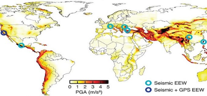
Crowdsourcing to Facilitate Earthquake Early Warning Implementation to Reduce the Impact of Future Earthquakes
The 7.9-magnitude earthquake that struck Nepal on August 25, 2015 has killed more than 5,000 people. Many thousands have been injured and hundreds are still missing or trapped under rubble.

AAG Honors Esri Executive Bill Derrenbacher for Lifetime Achievement
Pioneer of Applied Geography Receives James R. Anderson Medal of Honor Redlands, California—Bill Derrenbacher, Esri executive adviser, was awarded the Association of American Geographers (AAG) James R. Anderson Medal of
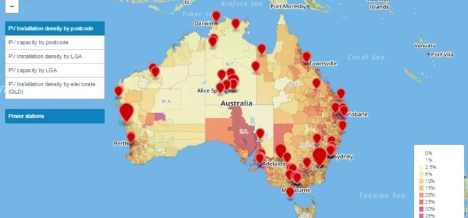
Prestigious award for Australian Solar Mapping Tools
The Australian PV Institute (APVI) has been awarded the national ENERGY GLOBE Australia Award for its suite of live generated solar photovoltaic (PV) maps and tools. ARENA CEO Ivor Frischknecht

NASA Training on Remote Sensing Observations for Flood Management
The goal of the NASA Applied Remote Sensing Training (ARSET) is to increase the utility of NASA earth science and model data for policy makers, regulatory agencies, and other applied

DigitalGlobe Produces the World’s First Complete and Consistent High Resolution Satellite Imagery Base Map of Africa
LONDON–(BUSINESS WIRE)–Apr. 28, 2015– DigitalGlobe, Inc. (NYSE: DGI), a leading global provider of high-resolution earth imagery and geospatial solutions, today announced the general availability of its Basemap +Vivid product for
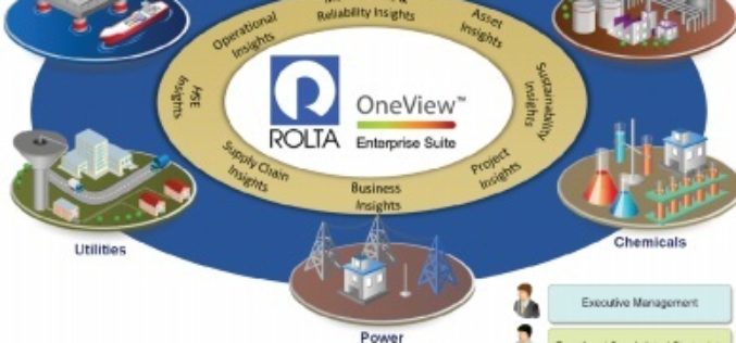
Rolta Unveils Rolta OneView 6.0
Cloud-ready rapidly deployable Big Data Analytics Solution April 30, 2015 – Mumbai – Rolta today announced a major release of Rolta OneView 6.0 with greatly enhanced features and functionality to provide

OGC Calls for Participation in GeoSemantics Summit
30 April 2015 – On 3 June 2015, the Open Geospatial Consortium (OGC) GeoSemantics Domain Working Group will host a summit, “GeoSemantics: Standards Intersect Ontologies”. This summit will be part
