
Archive

NIDM Emphasizes On the Need of Digital Mapping
In recent news by ToI, ahead to the planning of Kumbh Mela in Nashik, the National Institute of Disaster Management (NIDM) has suggested digitised mapping of Nashik to create a

Cuba Promotes Use of Satellite Remote Scanning and Detecting
Havana, May 7 (Prensa Latina) Cuba shows a sample called “A Look to the Outer Space”, which promotes the use of satellite remote scanning and detecting to be used for

Exelis ENVI Analytics Now Available on DigitalGlobe’s Geospatial Big Data Platform
BOULDER, Colo. – May 6, 2015 – (BUSINESS WIRE) – Exelis (NYSE: XLS) and DigitalGlobe, Inc. (NYSE: DGI) have agreed to provide a new commercial offering of cloud-based ENVI earth science analytics for
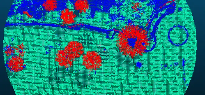
Forest Canopy LAI and Vertical FAVD Profile Inversion from Airborne Full Waveform LiDAR Data Based on a Radiative Transfer Model
Forest Canopy LAI and Vertical FAVD Profile Inversion from Airborne Full Waveform LiDAR Data Based on a Radiative Transfer Model – Han Ma, Jinling Song and Jindi Wang Abstract: Forest

RIEGL LIDAR 2015 User Conference: Hong Kong Opening with Impressing Keynotes and Significant RIEGL Product News
RIEGL LIDAR 2015 User Conference Hong Kong and Guangzhou: Hong Kong Opening with Impressing Keynotes and Significant RIEGL Product News RIEGL launched the first part of its ambitious LIDAR 2015 “One Conference, Two

Bramor gEO UAV from C-ASTRAL Reviewed by the Geo-Matching Community
The Geo-matching.com website features a selection of the most important geomatics equipment, including UAS for Mapping and 3D Modelling. At www.geo-matching.com, you can compare product specifications and read users’ reviews
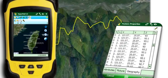
Perfection and Profession. Meet the Brand New SuperPad 3.3!
It is really our pleasure to share with you that the latest version of the SuperPad released for global users. Supergeo R&D team have been focusing on usability and reliability
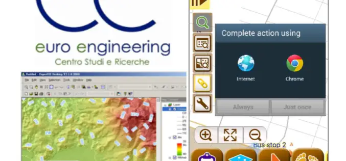
Euro Engineering, Italy Raises Research Value by Using SuperGIS
Supergeo, the leading GIS software and solution provider, announces that Centro Studi e Ricerche Euro Engineering – Soc. Coop. a r.l. (Euro Engineering) raises their research quality by using SuperGIS

ISRO Stresses on Research on Geospatial Technology
According to recent news by ToI, Indian Space Research Organization (ISRO) chairman A S Kiran Kumar stressed on the importance of cultivating a large student workforce for academic research especially

eXom Ready For Take-Off — sensefly’s Intelligent Mapping And Inspection Drone Now Available To Pre-Order
senseFly confirms release timings & technical specifications of its sensor-rich, multi-imaging rotary drone at Unmanned Systems 2015 (Hall B2, Booth 519) Unmanned Systems 2015, Atlanta, May 5, 2015 – Swiss
