
Archive
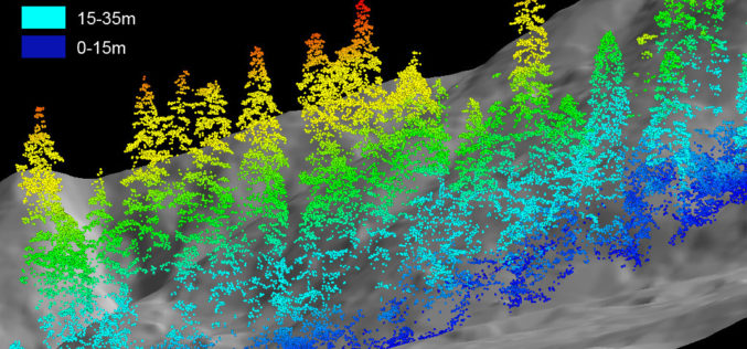
LiDAR Mapping Technique Finds Abandoned Mines in Forest
A project to determine the locations of abandoned mines in the Willamette National Forest could help firefighters and others avoid injuries. The Statesman Journal reports in a story on Saturday
RFP for Upgradation and Maintenance of NSDI’s India Geoportal
“Invitation for Expression of Interest for Proposal for Upgradation and Maintenance of NSDI’s India Geoportal” Department of Science and Technology, Government of India, invites Expression of Interest (EOI) in sealed
Esri Live Training Seminars on Utility Asset Inspection Using ArcGIS
Esri Live Training Seminars on Utility Asset Inspection Using ArcGIS Thursday, April 16, 2015 Learn how to configure and deploy focused ArcGIS maps and apps that support common inspection workflows.

Play Pac Man with Google Maps on Your Streets
Recently Google Maps has launched “Pac Man” in Google Maps. Team at Google Maps has coded a web application that lets users turn any city into classic arcade of game with hungry

Webinar: Getting Started with Geographic Calculator 2015
Getting Started with Geographic Calculator 2015 April 10, 2015 This Geographic Calculator session is geared toward new users that are just beginning to learn their way around the Geographic Calculator.
Bhuvan Bhujal Portal – Ground Water Prospects Information System
The National Remote Sensing and Application Centre (NRSC), India has recently launched a web application “Bhujal Portal”. Bhujal is sponsored project by Department of Drinking Water and Sanitation, Ministry of Drinking
3D Robotics (3DR) Announces DroneKit SDK and API for Developing Drone Apps
3D Robotics (3DR), North America’s largest consumer drone manufacturer, has released a new open software product called DroneKit – Software Development Kit (SDK) and Application Programming Interface (API) for drone app development. DroneKit allows developers
New Esri MOOC Tailored for Business Students
Redlands, California—Building on the success of its initial massive open online course (MOOC), Esri announces The Location Advantage, which is designed for recent graduates and current students majoring in business.

World’s Biggest Aerial LiDAR Survey to Reveal Angkor Wat Historical Secrets
Angkor, in Cambodia’s Northern Province of Siem Reap, is one of the most important archaeological sites of Southeast Asia and listed in world heritage sites by UNESCO. Stretching over some

Tribal Ministry to Use Satellite Mapping to Develop Water Bodies
The Ministry of Tribal Affairs (MoTA) is planning to use satellite mapping to identify potential water collection spots, which could be developed for fish culture and other purposes in order
