Archive
European Space Agency (ESA) Conducting Ocean Training Course 2015
As part of the Scientific Exploitation of Operational Missions (SEOM) programme element, the European Space Agency (ESA) is organising an advanced Ocean Remote Sensing Training Course, devoted to train the
PCI Geomatics Releases GXL 2015
PCI Geomatics, a world leading developer of remote sensing and photogrammetric software and systems, announced today the release of its GeoImaging Accelerator (GXL) 2015 – the latest version of the
Remote Sensing Centre to Zero-In On Water Sources in Maharashtra
March 05, 2013 – The Maharashtra Remote Sensing Application Centre will launch a web-based GIS of public drinking water sources in the state. The project will also involve creating a
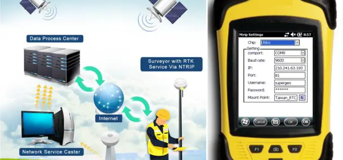
SuperPad Reveals NTRIP Solution to Achieve Centimeter Level Accuracy
Supergeo, the leading GIS software and solution provider, is going to release NTRIP solution on its Windows Mobile GIS app, SuperPad, for high accurate field data collection and geospatial workflow
Supergeo Expand Partnership with Géo.RM, France
Supergeo Technologies, the global leading GIS software and solution provider, announced the renewal of SuperGIS software contract with Géo. RM, France. The extended collaboration will continue bringing French-speaking users the
FOSS4G-Europe Conference – Submissions Deadline Extended!
The second edition of the FOSS4G-Europe Conference will be held at Politecnico di Milano in Como, Italy, from July 15th to 17th, 2015. A day of workshops will precede the
RIEGL LIDAR 2015 – New Sponsors and First Speaker Announcements!
RIEGL LIDAR 2015 May 5-8, 2015 in Hong Kong and Guangzhou (Canton), China Presentation slots and seats for RIEGL LIDAR 2015 are filling up fast! New sponsors and exhibitors have
Airborne LiDAR Datasets Covering Two Volcanic Fields and a River Confluence
OpenTopography is pleased to announce the release of three new LiDAR datasets covering two volcanic fields in Northern Arizona and Nevada as well as a river confluence in Colorado. The
Independent Report Highlights Esri as Leader in Global GIS Market
Esri and Partners Lead GIS Deployment in More than 10 Industries, Including 28 Percent Share of Electric Transmission and Distribution Market Redlands, California—ARC Advisory Group reports that Esri has a
New ASPRS Positional Accuracy Standards for Digital Geospatial Data Released
The American Society for Photogrammetry and Remote Sensing (ASPRS) is pleased to announce the release of the new Positional Accuracy Standards for Digital Geospatial Data. The new standards are available


