
Archive

University of Denver Offering Master and Graduate Certificate Course in GIS
Founded in 1864—just a few years after the city of Denver itself was founded—the University of Denver is one of the country’s premier private universities. The University’s 125-acre campus, a
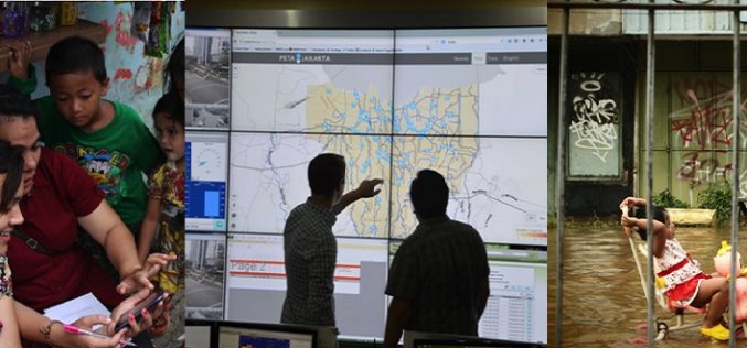
First-in-the-World: Indonesia is Using Tweets to Map Floods in Jakarta
Researchers have taken up the geospatial technology to a new horizon in Indonesia by using tweets from Twitter to map floods in Jakarta. Jakarta suffers from widespread annual flooding during
High-Resolution Land Surface Modeling Utilizing Remote Sensing Parameters and the Noah UCM: A Case Study in the Los Angeles Basin
High-Resolution Land Surface Modeling Utilizing Remote Sensing Parameters and the Noah UCM: A Case Study in the Los Angeles Basin – P. Vahmani and T. S. Hogue Abstract: In the

Enhanced Elevation Data for North and South America, Pacific Islands, Northern Europe
New Heights of Global Topographic Data Will Aid Climate Change Research The U.S. Geological Survey announced today that improved global topographic (elevation) data are now publicly available for North and

Autodesk Makes Design Software Free to Schools Worldwide
Design Software Leader Expands Reach of Free Education Offering to Prepare an Industry-ready Workforce Fulfilling its promise to expand access to its professional design software in education, Autodesk, Inc. (NASDAQ:ADSK)

SuperSurv 3.2 Supports iOS 8 and Enhances GPS Display
SuperSurv (iOS) 3.2, the field data collecting app for iPhone and iPad users, now fully supports iOS 8 and enhances GPS display with optimal user experiences. Developed by Supergeo, SuperSurv

India and US Set Up Joint Working Group for Mars Studies
In recent news by PTI, India and the US have set up an ISRO-NASA joint working group to explore the possibility of enhancing cooperation for the study of Mars. Jitendra Singh,

Orbit GT Releases Orbit Softcopy Version 11
Orbit GeoSpatial Technologies has released Orbit Softcopy version 11, the photogrammetric mapping solution from the Orbit GT portfolio. “Orbit Softcopy is the first version 11 upgrade within our Photogrammetry portfolio.“, says

USGS to Show Mountain Bike Trails on US Topo Maps
Get Your Wheels Spinning As part of the continued US Topo maps revision and improvement cycle, the USGS will be including mountain bike trails to upcoming quadrangles on a state-aligned

Avia-GIS Developed Apps to Combat Diseases Spread by Pests
In recent news by ESA, a consortium led by Avia-GIS in Belgium and supported by ESA has developed Vecmap – an all-encompassing software and services package including a smartphone app for
