
Archive

The OGC® adopts OGC Geo and Time Extensions Standard for OpenSearch
The Open Geospatial Consortium (OGC®) Members approved “OGC OpenSearch Geo and Time Extensions” as an OGC standard. This document defines an extension to the popular OpenSearch specification so that users

Total Station Errors
A Total Station is modern, automated and much more complicated combination of theodolite integrated with an electronic distance meter (EDM), microprocessor with an internal data storage or external data

Free SuperGIS Webinar on Facilitating Field Tasks by Mobile GIS
Facilitating Field Tasks by Mobile GIS Wednesday, May 7th; 11:00 AM – 12:00 PM (EDT, New York Time) Mobile GIS changes the way we capture and update field data. Geospatial information can

A GPS App to Fight Racism
The LICRA (International League against Racism and Anti-Semitism) has developed the first anti-racism mobile app for iPad and iPhone. The app is a unique and effective tool to reduce racism, anti-semitism
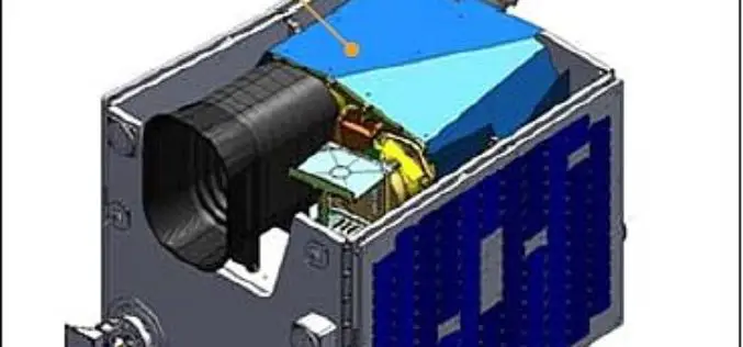
Kazakhstan to Launch its First EO Satellite on April 29
Kazakhstan first ever remote sensing or earth observation satellite, KazEOSat-1, is to be launched from Kourou, The Space Centre of French Guinea on April 29, 2014. The satellite system comprises
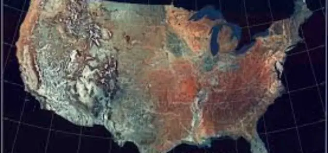
Revised West Virginia, New Jersey and Georgia Maps Feature New Design
Newly designed US Topo maps covering West Virginia, New Jersey and Georgia are now available online for free download US Topo maps now have a crisper, cleaner design – enhancing readability

South Africa get its First Space Geodesy and Geophysics Observatory
In recent news, the first Space Geodesy and Geophysics Observatory in Southern Hemisphere has been setup in South Africa. According to Acer Africa the observatory is located in the
Esri Opens Its Storytelling with Maps Contest
Redlands, California—April 22, 2014- Anyone who has ever created a story map, or wanted to, is invited to enter Esri’s Storytelling with Maps Contest. “Everything is fair game, including Story Maps you’ve

USGS Webinar: The National Elevation 3D Program (3 DEP)
A Conversation with the USGS: The National Elevation 3D Program (3 DEP) Tuesday, April 29, 2014 1:00 PM – 2:00 PM CDT The United States Geological Survey is embarking on

App to Forecast Storms Launched by Dubai Municipality
Dubai Municipality has launched a Android based app to forecast and monitor storms in 48 hours advance in Dubai. The app, Najam Sohail, is the name of app for early
