
Archive
Must have GPS Installed on all Vehicles by February 20
Ministry of Road Transport and Highways issued guidelines that owners of public service vehicles of cities with a population of over 10 lakh are required to get GPS (Global Positioning

PhD Positions in Satellite Remote Sensing at University of New South Wales
The University of New South Wales (UNSW) is one of Australia’s leading research and teaching universities. Established in 1949, it is ranked among the top 60 universities in the world,

Visakhapatnam Urban Development Authority to Implement GIS for Real Time Project Monitoring
Visakhapatnam Urban Development Authority is planning to introduce Geographical Information System (GIS) with an aim of displaying the latest status of its various projects as well as the areas under its

Google to Share Map Data with Game Developers
In recent news, Google’s Vice President of Niantic Labs John Hanke informed that Google is planing to make its trove of real-world map data available to game developers within the next

Kazakhstan to Launch Three Spacecrafts
In recent news, Kazakh Space Agency head Talgat Musabayev made the remark that Kazakhstan will launch three of its own spacecrafts from Baikonur Cosmodrome in 2014. Kazakhstan will launch one communication satellite
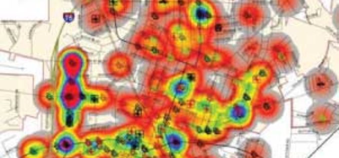
Mapping the Weekly Crime Report
Crime Analysis using GIS A COGS student is hoping that last year’s crime reports will help local police predict patterns in this year’s 911 calls. Brad Benham, a mapping student
EOI: Digitization, Georefrencing & Superimposition of Planning Permissions in Digital Landuse Map of Planning Area for Various Towns in MP
State institute for town planning (SITOP) invites the Expression of Interest (EOI) from national interested consulting firms of repute for “Digitigation, Geo-refrencing & Superimposition of Planning Permissions in Digital Landuse

The Bombay Greenway Project
Turning the railway into a greenway… The Railway in Bombay defines the linear city & dictates how 7 million people travel daily! The Railway into Greenway proposal envisions a 21st

Introducing a New Era in Airborne Mapping: The New RIEGL LMS-Q
The fully integrated RIEGL LMS-Q1560 ultra wide area airborne mapping system: Providing up to 800kHz PRR and 530,000 points/sec on the ground it can be used at up to 15,500

Geo-spatial Technology for Women Safety
In a recent news, the Cabinet Committee on Economic Affairs (CCEA), Government of India has approved a proposal of the Ministry of Home Affairs to establish an Integrated Computer Aided

