
What is Geodesy?
Geodesy is the science which deals with the methods of precise measurements of elements of the surface of the earth and their treatment for the determination of geographic positions on the surface of the earth. It also deals with the theory of the size and shape of the earth. Geodesy may be broadly divided into two branches, namely,
- Geometric Geodesy.
- Physical Geodesy.
There is a third one also, known as Satellite Geodesy. Dictionary meaning of Geodesy is ‘dividing the earth and measurement of the earth geometry’. Thus geometric geodesy appears to be purely geometrical science as it deals with the geometry (shape and size) of the earth.
Determination of geographical positions on the surface of earth can be made by observing celestial bodies, and thus comes under geodetic astronomy, but this can be included under geometric geodesy.
Earth gravity field is a physical entity and is involved in most of the geodetic measurements, even the purely geometric ones. The measurement of geodetic astronomy, triangulation and leveling, all make essential use of plumb line being the direction of gravity vector.
Thus, astro-geodetic methods which use astro determination of latitude, longitude, and azimuth and geodetic operations e.g. triangulation, trilateration, base measurement etc., may be considered as belonging to Physical geodesy fully as much as the gravimetric methods.
As a general distinction astro-geodetic methods come under geometric geodesy which use the direction of gravity vector, employing geometrical techniques, where as the gravimetric methods come under physical geodesy, which operate with the magnitude of ‘g’ using potential theory. A sharp demarcation is impossible and there are frequent overlaps.
Satellite Geodesy: Satellite geodesy comprises the observational and computational techniques which allow the solution of geodetic problems by the use of precise measurements to, from or between artificial , mostly near the earth satellites.
Applications of Geodesy:
- primary or Zero order triangulation, trilateration and traverse.
- The measurement of height above sea-level by triangulation or sprit levelling.
- Astronomically observations of latitude, longitude and azimuth to locate origins of surveys, and to control their direction.
- Crustal Movements. To detect changes in the relative positions on the ground, and in their heights above sea level.
- Observation of the direction of Gravity by astronomical observations for latitude and longitude.
- Observation of the intensity of Gravity by the pendulum and other apparatus.
- To deduce the exact form of earth’s sea level equipotential surfaces at all heights.
- Polar motion studies.
- Earth tides
- The separation between the Geoid and the mean sea level.
- Engineering Surveys.
- Satellite Geodesy: includes the modern techniques of positioning by space methods e.g. GPS, SLR and VLBI etc.
The Importance of Reference Surfaces in Geodesy
To understand how the shape and size of the earth is determined, three surfaces which are of interest to the geodesists have to be understood clearly. These surfaces are:
- Physical surface of the earth
- Geoid
- Reference Ellipsoid.
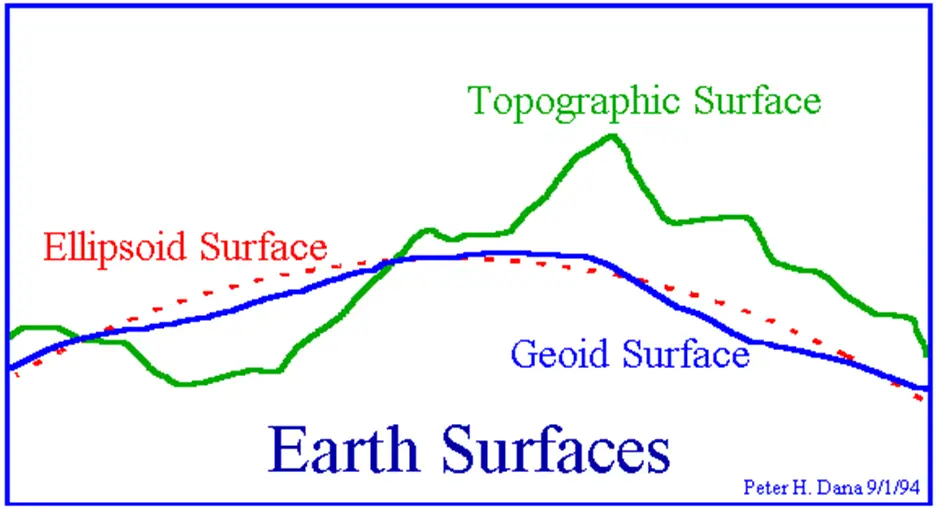
Figure 1: Three Surfaces of Earth
Also, Read – GPS Field Observation and Data Processing


Nice article, I am pleased at the way geodesy is eland here,,,can I get more information?
More information about geodesy.