Skip to content

GIS Resources

A Knowledge Archive…

  • GIS Resources Facebook
  • GIS Resources Twitter
  • GIS Resources Google+
  • GIS Resources Linkedin

Primary menu

  • Geo News
    • Tenders and RFP’s
  • GIS
  • GNSS
    • GLONASS
      • GLONASS Current Status
      • GLONASS Satellite Constellation
      • GLONASS Orbital Characteristics
      • GLONASS Signals
      • GLONASS Ground Control
      • GLONASS Development History
    • Virtual Reference Station
      • How VRS Work?
      • Challenges and Benefits of VRS
      • Errors can be Reduced in VRS
  • LiDAR
  • Photogrammetry
  • Remote Sensing
  • Surveying
  • Business
  • Resource Box
    • Apps & Software Updates
    • Courses
    • E-books
    • Free GIS Data
    • Geo Events
    • GIS Resources Magazines
      • Editorial Board
    • Geo Videos
    • Research Papers
    • Webinars
  • Jobs
  • About Us
    • Contact
    • Editorial Board
    • Advertise
    • Partners
    • Submit Press Release
    • Submit Article and Job

Tag: Tailwind UAV

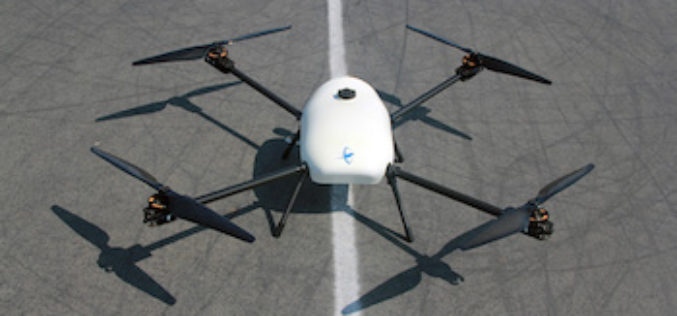
Skyfront Sets World Record for Drones with 4 Hour and 34 Minute Flight

  • By gisresources
  • September 18, 2017
  • No Comments

Skyfront invents hybrid-electric drone technologies to enable monitoring of large, remote assets in challenging terrain for the Utility, Agriculture and Energy industries. MENLO PARK, CA, SEPT. 12, 2017 – Skyfront, … read more →

job opportunities

Creative Commons License
GIS Resources is licensed under a Creative Commons Attribution-NonCommercial 4.0 International License.
Copyright © 2019 GIS Resources. All Rights Reserved.
Powered by: WordPress | Theme: Simple Catch