
Tag "satellite"
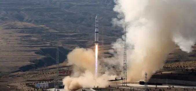
China Launches Three Remote Sensing Satellites – Jilin-1-04, Jilin-1-05 and Jilin-1-06
November 21 (ANI): China has launched three remote sensing satellites to promote commercial use for the remote sensing industry. The satellites — Jilin-1-04, Jilin-1-05, and Jilin-1-06 — were carried by a

DLR at Agritechnica in Hanover – Assistance from Space: Satellite Data for Digital Agriculture
Satellite information facilitates the modern management of agricultural land Agritechnica is the world’s largest trade fair for agricultural machinery, with 2900 exhibitors from 52 countries and 450,000 visitors (2015) Focus:
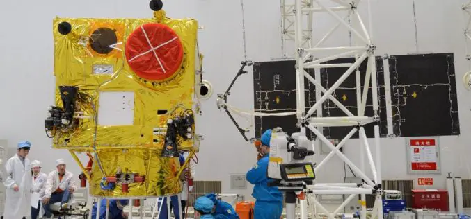
China Launched the 2nd Remote Sensing Satellite for Venezuela
According to recent news reported by Sputnik, China launched the second Venezuela Remote Sensing Satellite (VRSS-2) using a Long March-2D (Chang Zheng-2D) launch vehicle on October 09, 2017. Also known by
DLR Provides Satellite Data for Hurricane Harvey
DLR provides satellite data for Hurricane Harvey Radar images from TerraSAR-X German Aerospace Center (DLR) provides real-time recordings and archive data of the German radar satellite TerraSAR-X. DLR supports hurricane

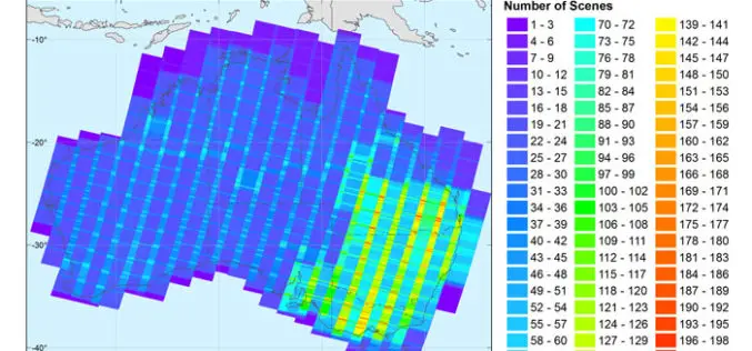
DigitalGlobe Delivers WorldView-4 High-Resolution Satellite Imagery to Power PSMA Australia’s Continent-scale Mapping Initiative
WorldView-4 Imagery To Become Available To All Commercial Customers On August 31 WESTMINSTER, Colo.–(BUSINESS WIRE)–Aug. 29, 2017– DigitalGlobe, Inc. (NYSE: DGI), the global leader in Earth imagery and information about our changing planet,

UrtheCast Announces the Signing of a Contract exceeding $100M for the Delivery of a SAR-XL Satellite as an “Accelerator Mission” for the OptiSAR™ Constellation
VANCOUVER, Aug. 14, 2017 /CNW/ – UrtheCast Corp. (TSX:UR) (the “Company”) announced today that it has entered into a contract with a confidential customer for the development and delivery of
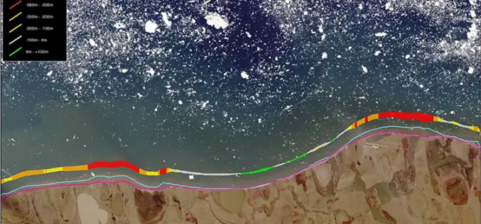
TCarta Marine Changes the Way Dynamic Environments are Managed and Monitored with Introduction of Vector Shorelines
DENVER, Colorado, USA, 8 August 2017 – TCarta Marine has made the world’s most dynamic environments easier to monitor and manage with the introduction of its new multi-scale Shoreline Products. Offered in

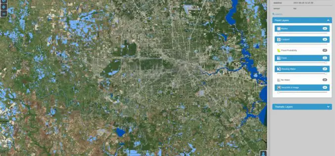
Flood Monitoring using SCATSAT-1 Satellite
Monsoon was active over different regions of India especially in Gujarat, Eastern Uttar Pradesh, Western Bihar, Assam and lately in West Bengal during mid July 2017. Heavy rains have created

SI Imaging Services Signs MoU with Luciad NV in Belgiumand G-Ros in Korea
On June 14th at the Grand Hyatte Seoul, the SI Imaging Services has signed a Memorandum of Understanding (MoU) with the Luciad NV in Belgium and its certified reseller in
New Open-source Software Enhances Satellite Geodesy Capability
Scientists from Geoscience Australia have released new software that will improve the ability to process big remotely-sensed satellite datasets. The new “PyRate” software being presented this week at the European
