
Tag "satellite"
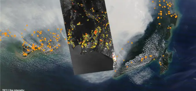
DLR Satellite TET-1 Delivers Detailed Images of the Fires in Indonesia
Indonesia is on fire – the island state is currently facing a bitter struggle against forest and peat fires on Sumatra and Borneo, most likely caused by illegal ‘slash and

China to Set Up 3 Civil Satellite Systems By 2020
BEIJING – China aims to finish building satellite systems for remote sensing, communications and navigation before 2020. The three satellite systems should be able to provide continuous and stable service,
Russia Plans to Create Renewed Earth Remote Sensing System
According to recent news in TASS, Russia is planning to create a renewed system of Earth’s remote sensing. Russian Deputy Prime Minister Dmitry Rogozin said, “we plan to create a renewed system
China Launches Tianhui-1 Remote Sensing Satellite
Beijing: China has successfully sent its third mapping satellite of the Tianhui-1 series into orbit on Oct. 26, 2015. Tianhui-1 will enhance the country’s ability to carry out scientific research, mapping and disaster
Belarus and Russia Partners to Define Specifications for a New Belarusian Remote Sensing Satellite
According to recent new by Sputnik, Belarus and Russia has joined their hands to announce technical specifications for a new Belarusian remote sensing satellite. President of the Belarusian Academy of Sciences Vladimir

China Launches Gaofen 9 Remote Sensing Satellite
China has launched Gaofen 9 remote sensing satellite at 04:45 UTC on Monday using Long March-2D launch vehicle from the 603 Launch Pad of the LC43 Launch Complex to orbit. It is
China Launches Yaogan-27 Earth Observation Satellite
According to CRIEnglish.com, China has successfully launched the Yaogan-27 remote sensing satellite into a scheduled orbit at 10:31 a.m. Beijing Time on Aug. 27,2015 from Taiyuan launch site in Shanxi Province, north
China to Open Doors for Commercial Remote Sensing Satellite
BEIJING: A Chinese province, one of the communist nations oldest industrial bases, plans to launch its first indigenous remote sensing satellite for commercial use in October. Northeast China’s Jilin Province
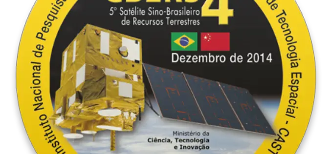
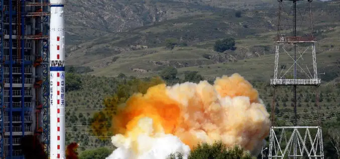
CBERS 4, Remote Sensing Satellite Jointly Developed by Brazil and China
CBERS 4, developed by the China Academy of Space Technology and Brazil’s National Institute for Space Research, the CBERS 4 was sent into Sun-synchronous orbit by a Long March 4B

Innovative Remote Sensing Applications Developed by Masdar Institute to be Implemented by Mohammed Bin Rashid Space Centre
Students and faculty from the Masdar Institute of Science and Technology have won top prizes for their innovative applications of high-resolution satellite data as part of a competition held by

