
Tag "remote sensing"

Merrick Releases MARS® 2017 Software Suite
Merrick & Company, a global leader in light detection and ranging (LiDAR), digital orthophotography, hyperspectral imaging, and geographic information systems (GIS) data integration, is pleased to announce the release of

Geo-tagging of Agricultural Land for Crop Management
According to recent by The Pioneer, the Ministry of Agriculture is going to sign a Memorandum of Understanding (MoU) with National Remote Sensing Center (NRSC), ISRO, for geo-tagging every piece
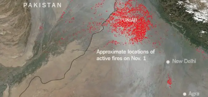
Punjab to use Remote Sensing and SMS Technology to Battle Against Crop Residue Burning
According to recent news reported by the Times of India, Punjab is set to make its battle against crop residue burning real time, with the state authorities using geospatial data

Earth-i Steps Up to Support the UK Space Industry
Earth-i has taken the opportunity to support the UK Space industry’s main gathering to discuss policy, progress and challenges by becoming a Gold Sponsor of the UK Space Conference 2017 held
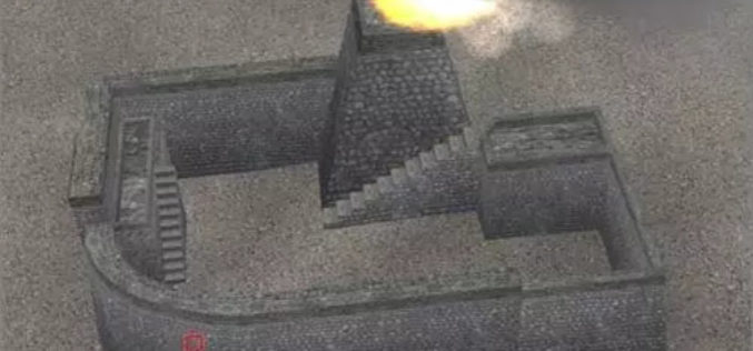
Chinese Scientists Use Remote Sensing Technology to Digitize Great Wall
Researchers from the Chinese Academy of Sciences (CAS) recently used remote-sensing equipment in their efforts to restore a vanished section of the Great Wall in Northwest China’s Xinjiang Uyghur Autonomous
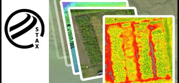
PCI Geomatics Releases STAX for UAV
MARKHAM, Ontario, Canada — March 07, 2017: PCI Geomatics, a world-leading developer of remote sensing and photogrammetric software and systems, announced today that it has released a new UAV image

World View and Ball Aerospace Demonstrate Persistent Remote Sensing from Stratollite Platform
Successful Proof of Concept Test for Commercial Use Tucson, Ariz., Feb. 23, 2017 – World View and Ball Aerospace successfully completed a Stratollite mission earlier this month, demonstrating early capabilities
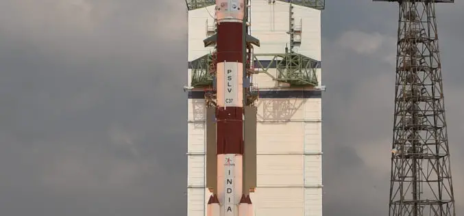
ISRO Successfully Launched Cartosat-2 Series Satellite Along with 103 Co-passenger Satellites
Sriharikota, India – In its thirty-ninth flight (PSLV-C37), ISRO’s Polar Satellite Launch Vehicle successfully launched the 714 kg Cartosat-2 Series Satellite along with 103 co-passenger satellites today morning (February 15,

BRICS Nations to Share Data from Remote Sensing Satellites
IANS – Bengaluru: The five-nation group of BRICS will share spatial data on natural resources from their remote-sensing satellites for utilizing space assets optimally, said a top Indian space official on

Training Course on GIS and Remote Sensing for Agricultural Resource Management
Training course on GIS and Remote Sensing for agricultural resource management April 17, 2017 – April 21, 2017 For optimum utilization of available agricultural land resources on a sustainable basis,

