
Tag "Photogrammetry"
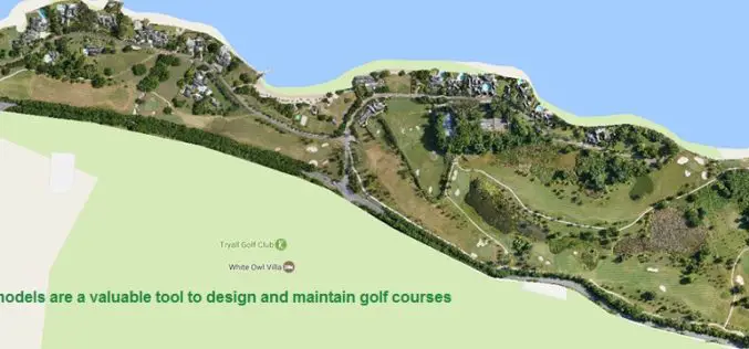
Three Reasons Golf Courses Are the Next Drone Mapping Territory
The emerald golfing greens have seen better days. According to the US National Golf Foundation, the number of players has almost steadily declined from over 30 million in 2005 (pre-recession),
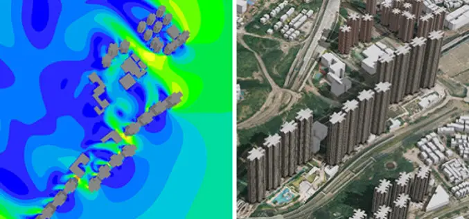
New 3D Mapping Technology for Smart City Development
The two most commonly used 3D mapping techniques are photogrammetry using satellite or aerial imagery, and laser scanning. The former offers greater accuracy in the horizontal direction and the latter

SimActive Used for Coastal Erosion Assessment with UAVs
SimActive Inc., a world-leading developer of photogrammetry software, is pleased to announce that Universiti Teknologi Malaysia (UTM) has chosen Correlator3D™ for its unmanned aerial vehicle (UAV) research. “We assessed photogrammetry

ICBA Workshop on Unmanned Aerial Vehicles for Remote Sensing and Photogrammetry
Unmanned Aerial Vehicles for Remote Sensing and Photogrammetry Monday, March 20, 2017 – Wednesday, March 29, 2017 International Center for Biosaline Agriculture (ICBA) is an international, non-profit agricultural research center
SimActive Enables Processing in the Cloud
November 29, 2016 – SimActive Inc., a world-leading developer of photogrammetry software, is pleased to announce that processing in the cloud is now officially supported by Correlator3D™. Users can subscribe to

Hexagon Showcases Geospatial Enterprise Solutions at ISPRS 2016
Hexagon AB, a leading global provider of information technologies that drive productivity and quality across geospatial and industrial enterprise applications, will showcase its geospatial enterprise solutions at XXIII ISPRS (International
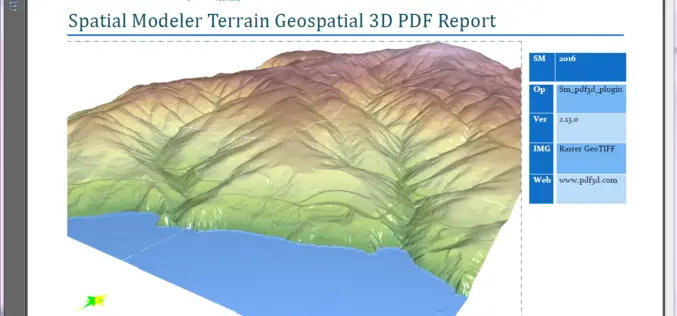
PDF3D Releases 3D Geospatial PDF Plugin for ERDAS IMAGINE at HxGN Live
PDF3D Plugin Released to Create High Quality Geospatial 3D PDF Documents from within ERDAS IMAGINE Spatial Modeler 2016. Anaheim California, June 13th, 2016 – Technological leaders, PDF3D, have today announced
SimActive and Delair-Tech Partner to Provide SNCF with a UAV Solution
SimActive Inc., a world-leading developer of photogrammetry software, is pleased to announce the purchase of multiple Correlator3D™ licenses by SNCF. The software is used in conjunction with UAVs from Delair-Tech,
DAT/EM Systems International Releases 7.2
Anchorage, Alaska, USA. January 5, 2016 – DAT/EM Systems International® released the 7.2 edition of DAT/EM software products including Summit Evolution™, LandScape™, Capture™, MapEditor™, Ortho+Mosaic™, Airfield3D™ and Contour Creator™. The
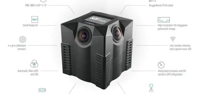
iSTAR Panoramic Camera to Support Digital Preservation of At-Risk Heritage Sites in Syria, the Middle East
Speed of capture, image quality and ease-of-use identified as key product attributes for sensitive mission Edinburgh, UK – December 17, 2015 – NCTech, the developer of reality imaging systems, today
