
Tag "mapping"

Satellite Mapping of Kedarnath to Boost Tourism
According to recent news by the Hindustan Times, the state government of Uttrakhand is set to conduct mapping of Kedarnath area, including the famed shrine town, using high-resolution satellite images

3D Mapping to Investigate Traffic Accident Cases
Singapore – According to recent news by The Star Online, traffic police officers from the Fatal Accident Investigation Team (FAIT) of Singapore are recreating event of accident site using 3D

China Adopts Revised Surveying and Mapping Law – Protecting National Security & Raising Public Awareness
China – April 28, 2017 – China’s top legislature Thursday passed a revised surveying and mapping law, protecting geographic information security and raising public awareness of national territory. The legislation

Uttar Pradesh: New Government Schools Only After GIS Mapping
Uttar Pradesh, India – According to recent news by The Hindustan Times, Uttar Pradesh will now get new government-run primary and upper primary schools only after completion of Geographic Information System
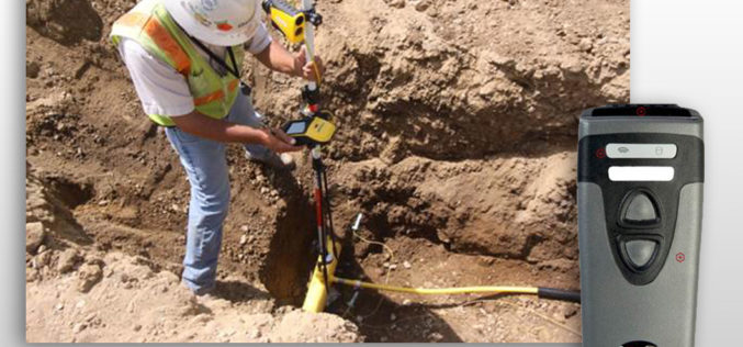
CartoPac Unveils Barcode Scanner Solution for Gas Utility Pipeline Mapping
CartoPac Unveils Barcode Scanner Solution for Gas Utility Pipeline Mapping Integrated Hardware, Software Included FORT COLLINS, Colorado, USA, 27 April 2017 – CartoPac International Inc., an enterprise mobile software and
China Unveils Results of First National Geoinformation Survey
China boasts a total of 7.56 million square kilometers of vegetation cover, while buildings cover 153,000 square kilometers of land, the State Council Information Office unveiled at a news briefing

3D Mapping of Delhi Metro Station to Help CISF
New Delhi, India – According to recent news the DNA, all the major Delhi Metro stations have gone through the 3D mapping, this shall certainly help Central Industrial Security Force (CISF)

Bluesky Launches New Online Resource for Geographic Information of Ireland
Aerial mapping company Bluesky has launched a new online Mapshop to serve the rapidly expanding mapping and geographic information industry in Ireland. With tens of thousands of square kilometres of

The Power of Offline Processing: Why Desktop is Essential for Drone Mapping in Agriculture
Part 2: Processing in the Field In Part 1 of this mini-series we went over why it makes sense in agriculture to import images directly to Pix4Dag Desktop. We concluded that
World Bank in Partnership with AEDB Launched a Series of New Solar Potential Maps for Pakistan
According to recent news reported by The news International, The World Bank, in partnership with the Alternative Energy Development Board (AEDB) has recently launched a series of new solar maps for

