
Tag "LiDAR"

LizardTech to Demonstrate a UAV Workflow at the Esri Southwest User Conference
SEATTLE, Wash. – LizardTech®, a provider of software solutions for managing and distributing geospatial content, will give a UAV oriented presentation at the Esri Southwest User Conference in Sante Fe,

Global Mapper V16 Released with 3D Tools Including HD Fly-Through
Blue Marble Geographics (bluemarblegeo.com) is pleased to announce the release of Global Mapper version 16. This major release includes many significant updates and new tools for working with 3D data.
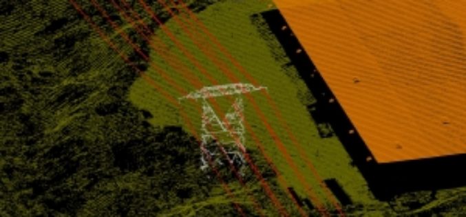
Leica Geosystems Releases ALS80 Next Generation LIDAR Mapping Solution with Market-Leading Productivity
Leica Geosystems introduces its next generation of airborne LiDAR solutions, the Leica ALS80. By incorporating advanced laser technology, new high-speed point cloud generation and viewing software, faster acquisition

DOST-UP’s Plane to Fly in ARMM to Chart Hazard Map
Manila, April 29 — The Department of Science and Technology (DOST) will fly a plane over the Autonomous Region of Muslim Mindanao in August to survey the region for hazard preparedness. The

NASA’s Double Pulse Laser- LiDAR to Study CO2
In recent news, a team of engineers at NASA Langley Research Center has developed world’s first double-pulsed laser system that make measurements of CO2 with highest degree of accuracy, all

Out-Of-This-World Satellite Images Help Monitor The Environment
The new Centre for Applied Earth Observation will use images from satellites, aircraft, and the International Space Station to monitor globally important environmental issues such as changes in forestry activity

SPDLib an Open Source Software for LiDAR Processing
SPDLib is an open source software for processing for processing LiDAR, including data captured from airborne and terrestrial platforms. The sorted pulse data (SPD) software library along with a collection of tools for processing traditional discrete

Shift to LIDAR in Global GIS Market in Transportation Industry
Research and Markets, are the leading source for international market research and market data has announced the addition of the “Global GIS Market in Transportation Industry 2012-2016″ report. The
