
Tag "LiDAR"

Geospatial Research Program Seeks Project Applications
FAYETTEVILLE, Ark. – The Spatial Archaeometry Research Collaborations (SPARC) Program, a National Science Foundation-funded initiative at the Center for Advanced Spatial Technologies at the University of Arkansas, is accepting applications

BAE Systems to Develop Airborne Mine-Hunting LIDAR for Manned and Unmanned Aircraft
Electro-optics engineers at BAE Systems are designing a multi-sensor suite and onboard processing to detect, identify, and pinpoint moored and drifting sea mines from manned and unmanned aircraft. Officials of the

Learn to Make Decisions Using Lidar Data and Geographic Information Systems
New Esri Workbook Teaches Analysis Skills, Combining Lidar Data and ArcGIS Software Redlands, California—A new book published by Esri teaches how to use geographic information system (GIS) software to analyze

Philippine Use LiDAR to Maps out Renewable Energy Resources
The Department of Science and Technology (DOST), Government of Philippine for applications of its Light Detection and Ranging (LiDAR) technology and maps out possible renewable energy resources through the PhiLiDAR

Gandhi Ashram Goes Under LiDAR Scan and Digitally Store
Mahatma Gandhi’s residence at Sabarmati Ashram – Hirday Kunj has under gone for LiDAR scanning to digitally store heritage building. This move has taken under a pilot project for the Gandhi

Webinar: Take Control of Your Geospatial Data with 1 Simple Platform
Take Control of Your Geospatial Data with 1 Simple Platform Thu, Oct 1, 2015; 9:30 PM – 10:30 PM IST, 12:00 PM – EST Learn how to manage your data with
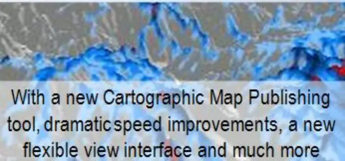
Global Mapper v17 Now With New Multi-View Interface and Enhanced Cartographic Layout Tools
Blue Marble Geographics has announced the release of Global Mapper version 17. This major release offers numerous new and improved geospatial tools, functional upgrades, and performance improvements throughout all areas of
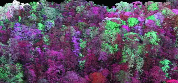
Laser Based Forest Mapping Instrument for Space Station
Laser-based technology will enable unprecedented measurements of 3-D forest structure A laser-based instrument for mapping the 3-D structure of Earth’s forests has passed a major milestone toward deployment on the

Mapping Australia’s Dinosaurs Landscape Using LiDAR and Drones
According to recent news by BBC, Scientists are trying to reconstruct ancient Australian landscapes once roamed by some of the biggest dinosaurs. The 130-million-year-old footprints are virtually the only record of

Webinar on Transition of ENVI Analytics from Desktop to Web
Webinar on Transition of ENVI Analytics from Desktop to Web Tuesday, September 15, 2015 1:30 pm Singapore Time (Singapore, GMT+08:00) Geospatial imagery is used more and more across industries because
