Skip to content
GIS Resources

GIS Resources

A Knowledge Archive…

  • GIS Resources Facebook
  • GIS Resources Twitter
  • GIS Resources Google+
  • GIS Resources Linkedin

Primary menu

  • Geo News
    • Tenders and RFP’s
  • GIS
  • GNSS
    • GLONASS
      • GLONASS Current Status
      • GLONASS Satellite Constellation
      • GLONASS Orbital Characteristics
      • GLONASS Signals
      • GLONASS Ground Control
      • GLONASS Development History
    • Virtual Reference Station
      • How VRS Work?
      • Challenges and Benefits of VRS
      • Errors can be Reduced in VRS
  • LiDAR
  • Photogrammetry
  • Remote Sensing
  • Surveying
  • Business
  • Resource Box
    • Apps & Software Updates
    • Courses
    • E-books
    • Free GIS Data
    • Geo Events
    • GIS Resources Magazines
      • Editorial Board
    • Geo Videos
    • Research Papers
    • Webinars
  • About
    • Editorial Board
    • Advertise
    • Partners
    • Submit Press Release
    • Submit Article and Job
  • Contact

Tag: Hyper Spectral

India Successfully Launches Hyper-Spectral Imaging Satellite (HysIS)

  • By gisresources
  • November 29, 2018
  • No Comments

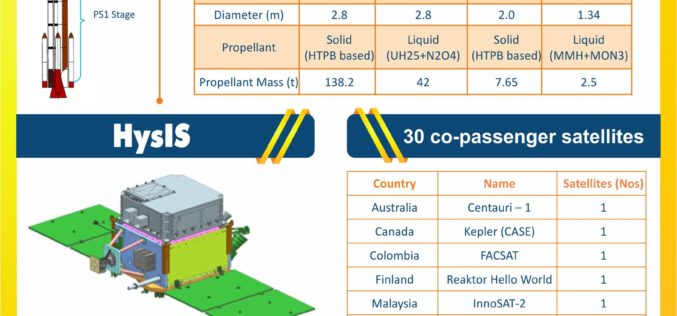
Nov 29, 2018 – ISRO – Today, the Indian Space Research Organisation’s (ISRO) Polar Satellite Launch Vehicle (PSLV-C43) successfully launched 31 satellites from Satish Dhawan Space Centre (SDSC) in Sriharikota. The … read more →

USDA Funds Bodkin Design to Develop UAV Sensor for Precision Agriculture

  • By gisresources
  • November 3, 2016
  • No Comments

Bodkin Design & Engineering, LLC has been awarded a $100,000 contract from the U.S. Department of Agriculture (USDA) to develop a compact hyperspectral imager for UAV platforms. This unique camera … read more →

job opportunities

Creative Commons License
GIS Resources is licensed under a Creative Commons Attribution-NonCommercial 4.0 International License.
Copyright © 2019 GIS Resources . All Rights Reserved.
Powered by: WordPress | Theme: Simple Catch