
Tag "geospatial"

Blue Marble Geographics Announces First Certified Trainer of Global Mapper
Blue Marble Geographics (bluemarblegeo.com) is pleased to announce that Engesat International S.A. of Brazil has successfully completed the training certification program. Together with his team, Laurent Martin, owner of Engesat
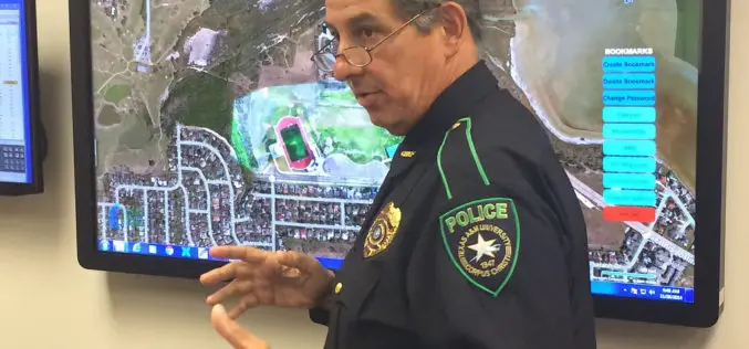
Mapping Application “SituMap”- Lets Emergency Responders See Scenes Virtually
CORPUS CHRISTI, Texas – A mapping application that lets first responders quickly and easily “see” an emergency situation with a digital command center is heading to the commercial market. The
UNESCO and UNITAR-UNOSAT Signed an Agreement to Protect Heritage Using Geospatial Technologies
UNESCO and UNITAR (the UN Institute for Training and Research) have signed an agreement to protect cultural and natural heritage sites with the latest geospatial technologies. It was signed at

USAID Learning Lab webinar: Going Geospatial with Impact Evaluations
Researchers at AidData have employed cutting-edge geospatial impact evaluation (GIE) methodologies to create new cost and time efficient ways to measure programmatic impact. The AidData Center for Development Policy is a

Michigan Launch Portal for Free Geospatial Data
State of Michigan has launched a portal for citizens to access and download free geospatial data about their state. The data is available for government, business and public use, with

Leica Introduce Leica Pegasus: Backpack Industry First Wearable Reality Capture
Leica Geosystems announced the commercial availability of Leica Pegasus: Backpack this week at HxGN LIVE. Leica Pegasus: Backpack is first of its kind in geospatial industry. It comes with a

Orbit GT and Genesys, India, sign Reseller Agreement
Orbit GT is proud to announce that Genesys, India has been selected as Reseller of Orbit GT Mobile Mapping software products. “We are pleased to have signed a Reseller Agreement

Geodesign: Change Your World – by Pennsylvania State University
What happens when creativity and science come together? The power to design our world is unleashed, providing tools to inform choices about how we live! Geodesign is the glue—it’s a

Saab and DigitalGlobe Announce Vricon Joint Venture to Create the Globe in 3D
Vricon will create high resolution elevation products and accurate, immersive 3D products with unmatched coverage and delivery timelines Defense and security company Saab and DigitalGlobe, Inc. (NYSE:DGI), a leading global

Airbus Defense and Space and Hexagon Geospatial Partner to Provide Access to Data in Smart Applications
May 26, 2015 – Airbus Defense and Space and Hexagon Geospatial have partnered in a new content-sharing program that will enable end-users to have access to Earth Observation data and software

