
Tag "geospatial"

Trimble Reports Third Quarter 2016 Results
– Third Quarter 2016 Revenue $584.1 million – GAAP Diluted Earnings Per Share $0.15; Non-GAAP Diluted Earnings Per Share $0.33 SUNNYVALE, Calif. , Nov. 1, 2016 /PRNewswire/ –Trimble (NASDAQ: TRMB)

Sharjah to Conduct GIS Survey of Labour Housing Facilities
According to the recent news, the Sharjah Labour Standards Development Authority (SLSDA) is planning to adopt geographic information system (GIS) and mobile apps to survey labour accommodation in Sharjah. The Sharjah
OGC Requests Comments on Proposed Quality of Service and Experience DWG
The Open Geospatial Consortium (OGC®) requests comments on the charter for a proposed Quality of Service and Experience (QoSE) Domain Working Group (DWG). Spatial data now plays a critical role

Sanborn Completes Kentucky County Aerial Project
Delivers Ortho and Oblique Imagery on Time to Boone County GIS Colorado Springs, Colo. (Oct. 24, 2016)—The Sanborn Map Company, Inc. (Sanborn) has completed a project for Boone County GIS
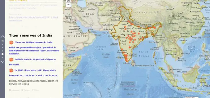
Why should we save Tigers – A Story Map
Contributed By:- The tiger is one of the largest and most awesome predators in the world. This species undoubtedly fascinates every eye it meets. Tiger is solitary and territorial and
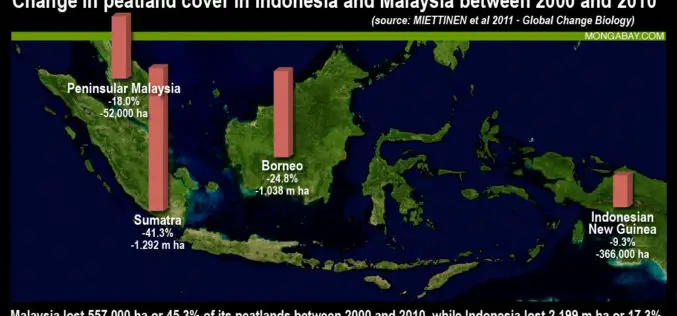
Jakarta Adopted LiDAR To Map and Protect Peatland Forests
According to recent news by The Jakarta Post, the Government of Indonesia has started producing a detailed peatland map using light detection and ranging (LiDAR) technology to better manage the nation’s

Waikato Regional Council, New Zealand Developed GIS-based Innovative Tool for Soil Conservation
New Zealand – An innovative tool to support soil conservation developed by Waikato Regional Council land and soil scientist Dr. Reece Hill made it into the finals of two categories
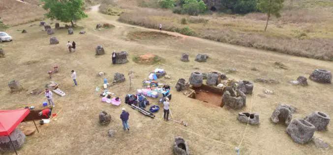
Archaeologists Use Drones to Build 3D Virtual-Reality Map
Archaeologists at The Australian National University (ANU) and Monash University are conducting a trial of new technology to build a 3D virtual-reality map of one of Asia’s most mysterious sites

Sri Lanka Setting Up National Spatial Data Infrastructure for Development
According to recent news, Sri Lanka’s Survey Department is setting up national spatial data infrastructure where spatial or location-based information can be better used and shared by both the government
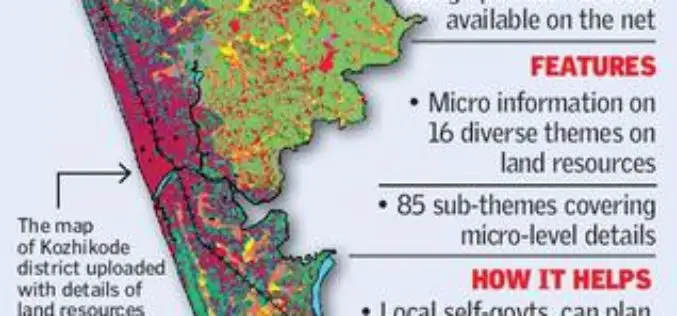
Kerala Launches GIS-based Land Information System
According to recent news by The Hindu, Kerala State Land Use Board (KSLUB) has launched Geographical Information System-based Land Resources Information System (LRIS). A 20-member team of the KSLUB has come out
