
Tag "GeoNews"

ASTEC Launches Space-based Program for Empowering Panchayati Raj Institutions
Guwahati, India -According to recent news reported by The Assam Tribune, the Assam Science Technology and Environment Council (ASTEC) has launched outreach activities for space-based projects Empowering Panchayati Raj Institutions

TomTom Inaugurates its First Global Innovation Hub in Pune, India
Aims to increase India headcount to 1000 by end of 2016 Pune, India, 30 August, 2016 – TomTom (TOM2) today inaugurated its first global state-of-the-art Innovation Hub in Pune. The

Get Ready for the New Small Drone Rule!
A new world of opportunities for drone operators opens next week on August 29 when the new small drone rule for non-hobbyists becomes effective. The Federal Aviation Administration (FAA) wants

Egypt to Map Archaeological Sites
A map of all of Egypt’s archaeological sites and museums has been created and will be launched for the first time on sites around the country The Geographic Information System

Two UN Agencies Adopted Geospatial Technologies to Protect Cultural Heritage
Two United Nations agencies (UNOSAT and UNITAR) have signed an agreement to protect cultural and natural heritage sites by using the latest geospatial technologies, including a satellite imaging system. The

DigitalGlobe to Announce Second Quarter Financial Results on July 28, 2016
WESTMINSTER, Colo.–(BUSINESS WIRE)–Jul. 14, 2016– DigitalGlobe, Inc. (NYSE: DGI), a leading global provider of commercial high-resolution earth observation and advanced geospatial solutions, will announce its second quarter 2016 financial results
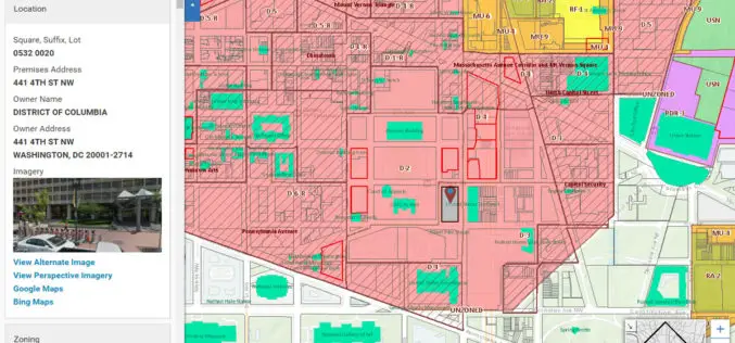
Blue Raster Incorporates Esri Technology into DC Office of Zoning Map
Constituents Can Leverage Open Data through Mobile Devices for Easy Access to Detailed Zoning and Planning Information Redlands, California—Esri has announced that the Washington, DC, Office of Zoning (DCOZ) has released
EMSA Expands Use of RADARSAT-2 Information for Maritime Applications
Richmond, BC – MacDonald, Dettwiler and Associates Ltd. (“MDA” or the “Company”) (TSX: MDA), a global communications and information company, has recently (July 13, 2016) announced that it has signed

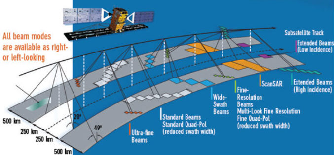
25 Years Ago – Europe’s First Earth Observation Satellite Was Launched
• First European radar satellite ERS-1 revolutionised satellite Earth observation by revealing never before seen details • ERS satellite programme laid the foundations for modern radar satellite technology and applications

China Estimates Decline in Summer Crop Yield
According to recent news by The Institute of Remote Sensing and Digital Earth (RADI) under the Chinese Academy of Sciences (CAS), China’s summer crop yield is set to drop for
