
Tag "Geocoding"
Startup EarthDefine Uses AI for Building Footprint Geocoding
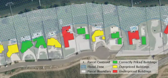
EarthDefine, a provider of high-resolution geospatial spatial data that uses artificial intelligence (AI) to analyze aerial and LIDAR imagery, today announced the release of an updated building footprint database, which

OGC Seeks Public Comment on Proposed Geocoding API Standards Working Group
September 5, 2017 – The Open Geospatial Consortium (OGC®) is requesting comments on the draft charter for an OGC Geocoding API Standards Working Group (SWG). Geocoding is the act of linking

Pitney Bowes Geospatial API Providing Location Intelligence for Data Analytics Now Available as a SaaS Subscription Offering on AWS Marketplace
STAMFORD, Conn., November 17, 2016 – Pitney Bowes (NYSE:PBI), a global technology company providing innovative products and solutions to power commerce, today announced that the Pitney Bowes Geospatial API is
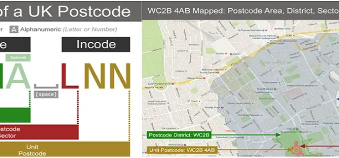
Understanding UK Postcodes and Using Them in Geospatial Systems
Contributed By:- Postcodes are very powerful within UK data – if you know the postcode of a geographical entity, you can geocode it, reasonably accurately, and using open and reliable

Webinar:- Innovations in Geocoding 2016: Weave location into the very fabric of your data to gain new efficiencies and insight
Event Information: Innovations in Geocoding 2016: Weave location into the very fabric of your data to gain new efficiencies and insight Tuesday, April 26, 2016 2:00 pm Eastern Daylight Time

Esri Training Seminar: Streamline GIS Workflows with ArcGIS Pro
Streamline GIS Workflows with ArcGIS Pro Thursday, January 29, 2015 Seminar Overview: ArcGIS Pro is a new desktop application included with ArcGIS 10.3 that is designed to help GIS professionals

Dubai to Implement 10-digit code for Geocoding
Municipality of Dubai is planning to launch a unique digital address system ‘Makani’ to find out any location in Dubai. An application called Makani supporting the Dubai grid addressing scheme has
