
Tag "Flood"
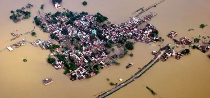
Bihar the Most Flood-prone State of India Aided by New Satellite Mapping
BHUBANESWAR, India (Thomson Reuters Foundation) – Every year Bihar is deluged by floods that submerge roads, destroy homes and wash away crops, leaving the disaster management authority struggling to monitor
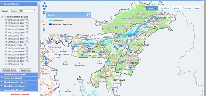
NRSC Released Updated Flood Hazard Atlas for Assam State
According to recent news by ISRO, the National Remote Sensing Centre (NRSC), ISRO, Hyderabad has released updated flood hazard atlas of Assam, a highly flood-prone state of India. Assam is
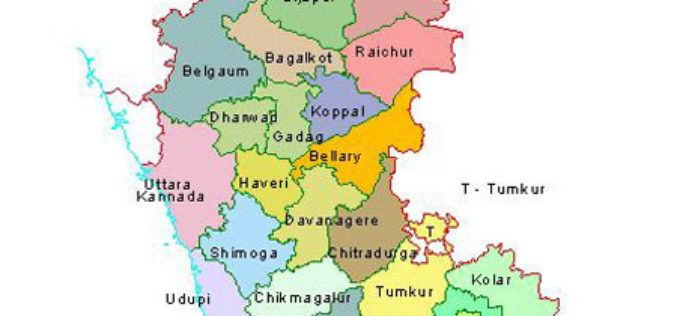
Karnataka to Identify Flood-prone Areas With New Maps and Geo-apps
Karnataka, India – According to recent news by the ET Tech, the Karnataka State Natural Disaster Monitoring Centre (KSNDMC) has initiated an exercise to develop high-resolution contour maps for Bengaluru

UNITAR: Geospatial Technologies for Flood and Drought Management in East Africa
In the past decade, countries in East Africa have experienced several flood and drought related disasters. These events have led to severe economic and livelihood loss, which in turn greatly

2nd Call for Expression of Interest ‘Quantifying Risk and Recovery of Disasters’
The European Commission has launched the second call for expression of interest for a limited number of risk and recovery activations through its Copernicus Emergency Management Service for Risk &

Odisha Goes for Flood Mapping
According to recent news by The New Indian Express, the Odisha State Disaster Mitigation Authority (OSDMA) has released a Flood Inundation Mapping (FIM) for Kendrapara, a coastal district of Odisha.
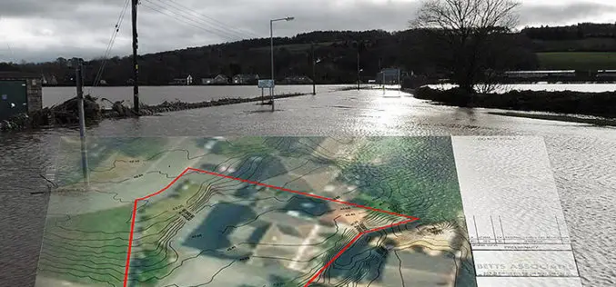
Bluesky’s 3D Aerial Maps Inform Flood Risk Assessments for Planning Applications
Aerial photography and detailed 3D height models are being used to assess the risk of flooding, and help development projects progress through the planning process. Working with Betts Hydro, part

Google and Facebook Launched Crisis Response Modules to Chennai Flood
Google and Facebook have launched their resources to extend help in relief work in Chennai flood, which have been affected by the annual northeast monsoon and associated floods. Google has launched

Bhuvan Tamil Nadu FS: A Mobile App to Monitor Flood Situation
Bhuvan Tamil Nadu FS App is a user-friendly mobile application which enables to collect and report for geo-tagged of flood information on various parameters such as type of damage and
Transform Your Flood Preparedness with ArcGIS
Transform Your Flood Preparedness with ArcGIS Wed, Dec 9, 2015 10:30 PM – 11:30 PM IST Time is running out to prepare for historic weather events fueled by El Niño.
