
Tag "ESRi"

Webinar: Integrated and Collaborative Geospatial Platform for Disaster Management
GIS provides an integrated platform for sharing data and applications for disaster management that supports all facets of Disaster Management including preparation, mitigation, response, recovery and rehabilitation. Find out how

The Wait is Over: LizardTech Launches GeoGofer for Powerful Image Searching and Sorting
Now users can tag and organize geospatial imagery quickly and easily; integrates with Esri Technology LizardTech®, a provider of software solutions for managing and distributing geospatial content, has launched GeoGofer,

Maps.com Launches “Field Trip Library” for K–12 Students
Interactive Exercises Based on the Esri Story Map Platform Redlands, California— (GIS) concepts while exploring global culture, regional patterns, and major historical events through interactive maps. Field trips are enhanced with
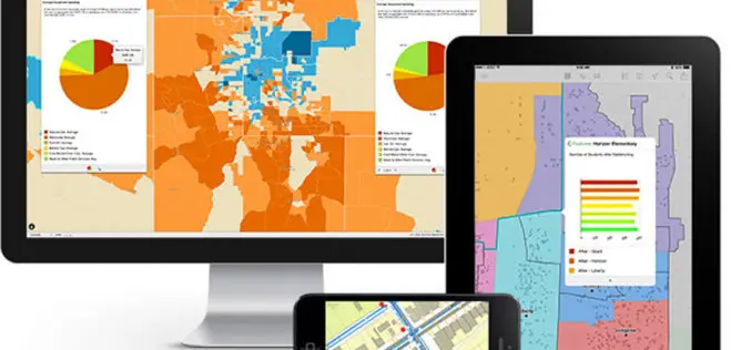
GFK’S New Digital Maps of China Point The Way To Regional Turnover Potential
Bruchsal, Germany, July 31, 2014. – GfK has expanded and updated its digital maps for China. This includes an unprecedented six-digit postcode map for China’s ten largest cities. GfK’s detailed

15th Esri India User Conference 2014
15th Esri India User Conference 2014 9-11 December 2014, Kempinski Ambience Hotel, Delhi It happens every winter in Delhi. The biggest GIS event of the year. The conference that 99
Esri and European Schoolnet Partner to Deliver Geographic Education Internationally
More Than 30 Ministries of Education to Gain Access to ArcGIS Online Redlands, California—School systems across Europe will soon have access to the world’s leading online mapping software for delivering
Explorer for ArcGIS Brings GIS to the Mac
Esri Releases First Native App for Apple OS X July 10, 2014, Redlands, California—Esri today released Explorer for ArcGIS on the Mac, a native OS X application to discover, view, and share maps.
New York to LA: History of America’s Maps in One App
Redlands, California—Two of the nation’s most authoritative mapping sources, the U.S. Geological Survey and Esri, have partnered to put the rich tapestry of U.S. Historical Maps into the hands of
Esri Announces Finalists of Climate Resilience App Challenge 2014
Company Unveils Top 13 Mobile Apps That Inspire and Provide Solutions to Combat Climate Change Redlands, California—Esri, the world leader in mapping technology, today announced the top 13 finalists of Esri
Esri Mapping Platform Secured for Federal Agency’s Use
ArcGIS Online Achieves Federal Information Security Management Act (FISMA) Authorization and Accreditation June 25, 2014 Redlands, California—The Esri ArcGIS Online platform is now authorized and accredited by the United States Department of

