
Tag "Disaster Risk"

Training Course on GIS and Remote Sensing For Climate Change Impact Analysis and Adaptation
Training Course on GIS and Remote Sensing For Climate Change Impact Analysis and Adaptation October 10 – October 14, 2016 This training will offer a set of methods and techniques
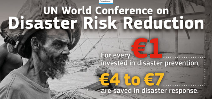
Sendai Framework for Disaster Risk Reduction
The Sendai Framework for Disaster Risk Reduction 2015-2030 provides a new global approach to disaster risk management policy and operations. In June 2016, the European Commission published an action plan

Training Course on GIS and Remote Sensing in Multi-hazard Early Warning Systems
Training Course on GIS and remote sensing in multi-hazard early warning systems July 25 – July 29 This training aims to develop the capacity of professionals mainly working in Disaster
UN Certificate Course on Geospatial Technologies for Disaster Risk Reduction
Geospatial Technologies for Disaster Risk Reduction in the Horn of Africa Geographic information systems (GIS) can be a very useful tool for the whole disaster management cycle starting from the
