
Tag "arcgis"

Vricon Joins Esri Partner Network to Expand Use of High-Resolution 3D Geodata
Redlands, California—Vricon, a leading provider of photo-realistic 3D mapping products and digital elevation models for the defense and security industries, is now a member of the Esri Partner Network. Vricon’s

What’s New With ArcGIS 10.4?
Data Visualization, Enterprise Resiliency Lead ArcGIS 10.4 Rollout The release of ArcGIS 10.4 marks improvements in data visualization, spatial analysis, and stronger support for on-premises implementations. “This release of ArcGIS
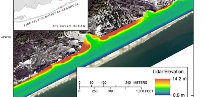
Terrestrial-based Lidar Beach Topography of Fire Island, New York
Abstract: The U.S. Geological Survey (USGS) St. Petersburg Coastal and Marine Science Center (SPCMSC) in Florida and the USGS Lower Mississippi-Gulf Water Science Center (LMG WSC) in Montgomery, Alabama, collaborated to
Indian Meteorological Department Deploys a Web GIS Solution to Deliver Real-time Weather Forecast
According to recent news by The Times of India, the Indian Meteorological Department (IMD) has deployed a web GIS solution in order to deliver real-time highway weather forecast updates. The Highway

Webinar on SAR Interferometry using SARScape tool for ArcGIS
Esri India Webinar on SAR Interferometry using SARScape tool for ArcGIS The use of Synthetic Aperture Radar (SAR) data has become increasingly popular in recent years, offering professionals in a
DAT/EM Systems International Releases 7.2
Anchorage, Alaska, USA. January 5, 2016 – DAT/EM Systems International® released the 7.2 edition of DAT/EM software products including Summit Evolution™, LandScape™, Capture™, MapEditor™, Ortho+Mosaic™, Airfield3D™ and Contour Creator™. The
UN Certificate Course on Geospatial Technologies for Disaster Risk Reduction
Geospatial Technologies for Disaster Risk Reduction in the Horn of Africa Geographic information systems (GIS) can be a very useful tool for the whole disaster management cycle starting from the
Transform Your Flood Preparedness with ArcGIS
Transform Your Flood Preparedness with ArcGIS Wed, Dec 9, 2015 10:30 PM – 11:30 PM IST Time is running out to prepare for historic weather events fueled by El Niño.

Keep Up-to-Date with ArcGIS API 4.0 for JavaScript
ArcGIS API 4.0 for JavaScript — for building interactive, compelling web applications — is available in beta. We’re leveraging advances in browser technology and the power of the ArcGIS platform
ArcGIS Earth Beta Now Available
Sign up for the beta program for ArcGIS Earth beta to download, Esri’s new 3D app. By participating in the program, you will be among the first to test-drive a prerelease

