
Tag "ArcGIS Online"

Learn What You Can Do with ArcGIS Spatial Analysis
Go Places with Spatial Analysis Free Online Course – Learn What Spatial Analysis Can Do for You This Massive Open Online Course (MOOC) is for people who know

The Wait is Over: LizardTech Launches GeoGofer for Powerful Image Searching and Sorting
Now users can tag and organize geospatial imagery quickly and easily; integrates with Esri Technology LizardTech®, a provider of software solutions for managing and distributing geospatial content, has launched GeoGofer,

Esri and European Schoolnet Partner to Deliver Geographic Education Internationally
More Than 30 Ministries of Education to Gain Access to ArcGIS Online Redlands, California—School systems across Europe will soon have access to the world’s leading online mapping software for delivering
Esri Mapping Platform Secured for Federal Agency’s Use
ArcGIS Online Achieves Federal Information Security Management Act (FISMA) Authorization and Accreditation June 25, 2014 Redlands, California—The Esri ArcGIS Online platform is now authorized and accredited by the United States Department of
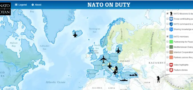
NATO HQ Launches Interactive Web Map Based on Esri Technology
People Can Now Easily View NATO Activities, Operations, Partners, Video, and More Redlands, California—The North Atlantic Treaty Organization (NATO) has just released “NATO on Duty,” an interactive, multi-media web map

PR: 3D Vegetation Library Delivers Advanced Models for Urban Design and GIS Professionals
Esri and E-on Software Provide 3D Toolset for Planning, Geodesign, and Other Industries Redlands, California—Esri, the leading provider of GIS solutions, and e-on software, the leader in 3D immersive nature
