
Tag "Aerial"

SI Imaging Services Signs MoU with Luciad NV in Belgiumand G-Ros in Korea
On June 14th at the Grand Hyatte Seoul, the SI Imaging Services has signed a Memorandum of Understanding (MoU) with the Luciad NV in Belgium and its certified reseller in
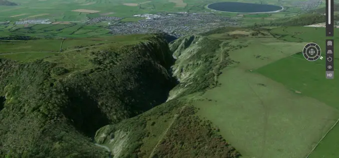
Explore Great Britain with OS’s Ultimate Adventure Planning Tool
Fresh from being named the UK Outdoor Industry’s Digital Product of the Year, OS Maps has become even better with the inclusion of an immersive 3D view of Great Britain in

Central Government Directs Chandigarh to Complete Aerial Mapping Project Within 1 Year
According to recent news by The Indian Express, The Union government on has directed the Chandigarh administration to complete the project of digitization of land records in the city within the

Sanborn Completes Kentucky County Aerial Project
Delivers Ortho and Oblique Imagery on Time to Boone County GIS Colorado Springs, Colo. (Oct. 24, 2016)—The Sanborn Map Company, Inc. (Sanborn) has completed a project for Boone County GIS

World’s Biggest Aerial LiDAR Survey to Reveal Angkor Wat Historical Secrets
Angkor, in Cambodia’s Northern Province of Siem Reap, is one of the most important archaeological sites of Southeast Asia and listed in world heritage sites by UNESCO. Stretching over some

Digital Aerial Solutions Expands Mapping Services with Purchase of Leica ALS80 Laser Scanner
Leica Geosystems Inc. today announced that Digital Aerial Solutions (DAS), a woman-owned small business based in Tampa, Fla., is the first company in North America to purchase the ALS80 laser

