Skip to content
GIS Resources

GIS Resources

A Knowledge Archive…

  • GIS Resources Facebook
  • GIS Resources Twitter
  • GIS Resources Google+
  • GIS Resources Linkedin

Primary menu

  • Geo News
    • Tenders and RFP’s
  • GIS
  • GNSS
    • GLONASS
      • GLONASS Current Status
      • GLONASS Satellite Constellation
      • GLONASS Orbital Characteristics
      • GLONASS Signals
      • GLONASS Ground Control
      • GLONASS Development History
    • Virtual Reference Station
      • How VRS Work?
      • Challenges and Benefits of VRS
      • Errors can be Reduced in VRS
  • LiDAR
  • Photogrammetry
  • Remote Sensing
  • Surveying
  • Business
  • Resource Box
    • Apps & Software Updates
    • Courses
    • E-books
    • Free GIS Data
    • Geo Events
    • GIS Resources Magazines
      • Editorial Board
    • Geo Videos
    • Research Papers
    • Webinars
  • About
    • Editorial Board
    • Advertise
    • Partners
    • Submit Press Release
    • Submit Article and Job
  • Contact

Tag: 3D Laser Scanning

NavVis Partners with PrecisionPoint to Bring the American Indoors Online

  • By gisresources
  • October 14, 2017
  • No Comments

13 October 2017 – NavVis, the global leader in indoor mapping, visualization, and navigation, announces a new partnership with PrecisionPoint, a leading reality capture solutions provider in the USA. PrecisionPoint is … read more →

Trimble Expands 3D Laser Scanning Portfolio with Addition of New TX6 and Improved TX8

  • By gisresources
  • October 12, 2016
  • No Comments

Offering Geospatial Professionals a Versatile Combination of Speed, Range and Accuracy to Support a Wide Variety of Surveying Applications HAMBURG, Germany, Oct. 11, 2016—Trimble (NASDAQ: TRMB) introduced today its new Trimble® … read more →

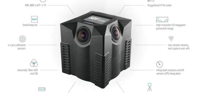
iSTAR Panoramic Camera to Support Digital Preservation of At-Risk Heritage Sites in Syria, the Middle East

  • By gisresources
  • December 18, 2015
  • No Comments

Speed of capture, image quality and ease-of-use identified as key product attributes for sensitive mission Edinburgh, UK – December 17, 2015 – NCTech, the developer of reality imaging systems, today … read more →

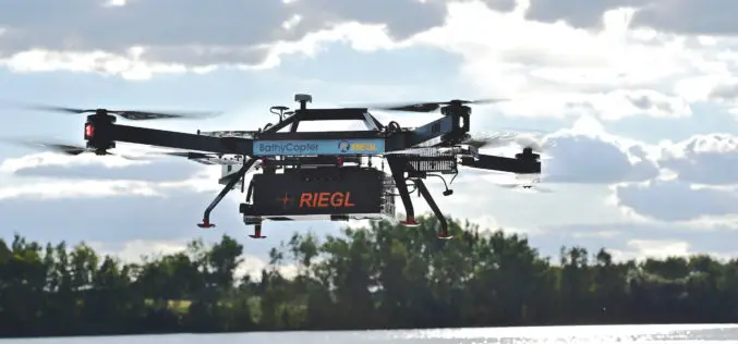
RIEGL with Impressive Display at INTERGEO 2015 in Stuttgart

  • By gisresources
  • September 16, 2015
  • No Comments

On the first day of INTERGEO RIEGL delivered an impressive display in Stuttgart! With a special UAV-area at booth E4.079, live demo UAV-flights at the outdoor area, and the unveiling … read more →

job opportunities

Creative Commons License
GIS Resources is licensed under a Creative Commons Attribution-NonCommercial 4.0 International License.
Copyright © 2019 GIS Resources . All Rights Reserved.
Powered by: WordPress | Theme: Simple Catch