The SI Imaging Services has signed a “Bulk Order Contract” with a geospatial data and analytics company URSA Space Systems Inc. The SI Imaging Services a leading provider of VHR satellite imagery especially representative of KOMPSAT series and the URSA Space System inc. is specialized in analytics using synthetic aperture radar (SAR) imagery.
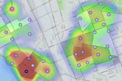
The main objective is to make a weekly monitoring based on the Area of Interest (AOI). With this agreement, SIIS will establish a specialized knowledge of the SAR, and cooperate with the company’s partner URSA to understand the analysis algorithms and share the interfaces.
The KOMPSAT-5 offers very high resolution SAR imagery up to 85 centimeters for change detection without weather condition.

About SI Imaging Services
SI Imaging Services is the exclusive worldwide marketing and sales representative of KOMPSAT series KOMPSAT-2, KOMPSAT-3, KOMPSAT-3A and KOMPSAT-5.
SIIS contributes Remote Sensing and Earth observation industries societies by providing very high resolution optical and SAR images through over 90 sales partners worldwide.
Customers from industries as well as government and international agencies are using KOMPSAT imagery for their missions and researches and achieve good results in several remote sensing applications such as mapping, agriculture, disaster management, and so on. SIIS started its business as a satellite image and service provider and extended its business to KOMPSAT operation. Learn more at http://www.si-imaging.com/
About URSA Space Systems Inc.
Ursa Space Systems Inc.’s(Ursa) vision is to become the standard for understanding global supply chains. Ursa’s insights bring a level of transparency to the world that will fundamentally change how markets move and policy makers manage risk.
Ursa aggregates and analyzes satellite-based radar to build proprietary data layers resulting in unbiased, consistent, all-weather location-based services and measurements. Ursa’s unique access to most of the world’s current and future Synthetic Aperture Radar satellites (SAR is a unique form of satellite imaging that uses radar to form images independent of lighting conditions and weather) and our unique understanding of how to apply machine vision and machine learning to SAR, gives the reliability that has hindered optical systems and allows Ursa to extract asymmetric value from a single image. Learn more at http://ursaspace.com/.