In a study, “Cropland/pastureland dynamics and the slowdown of deforestation in Latin America,” published in Environmental Research Letters by Jordan Graesser and et. al., brings out some interesting facts about the use of Remote Sensing and GIS technology in finding the dynamics of Cropland/pastureland in Latin America.
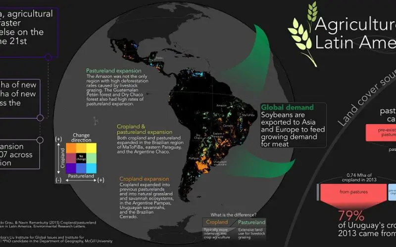
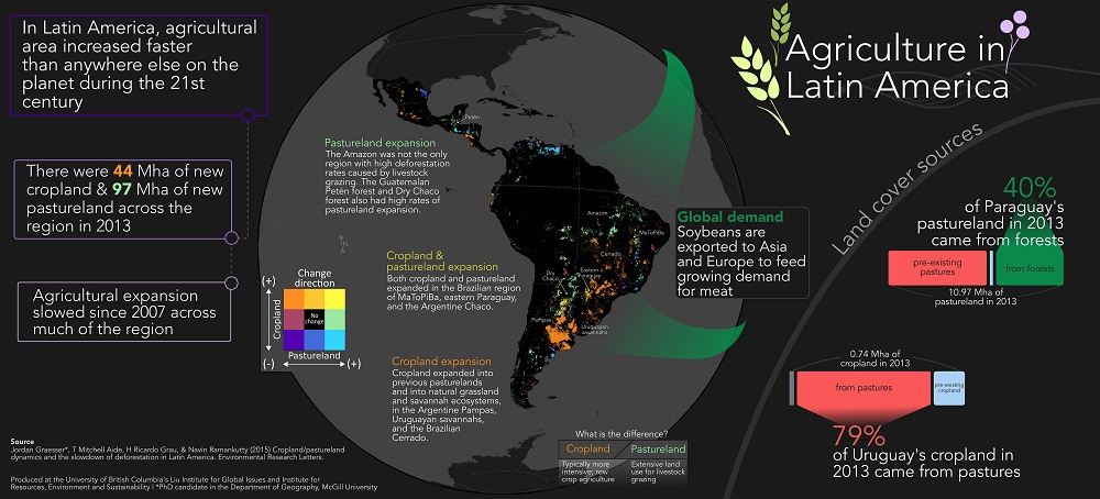
Latin America has the planet’s largest land reserves for agriculture and had the most rapid agricultural expansion during the twenty-first century. A large portion of the expansion replaced forests, as shown by many local and regional studies.
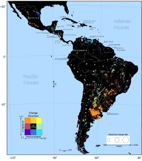
Cropland and pastureland change dynamics across Latin America (2001–2013). The colors illustrate the change direction, and the hexagon zone relative size represents the annual change rate. Zones shown in black had either insufficient cropland or pastureland, or the 13 yr, least squares polynomial trends were non significant (p < 0.01). Credit: Jordan Graesser
Latin America’s sparsely populated rural areas contain some of the planet’s most biodiverse and carbon-rich land reserves. Much of the region’s agricultural expansion is relatively recent, as expansion prior to the mid-1900s was limited by land access and technology in some regions and unfavorable climate and soils in others. But improved road infrastructure and green revolution technologies (1960 Green revolution) brought agricultural changes across Latin America.
The twenty-first century brought renewed expansion and the largest changes in agriculture area occurred during the 2000s, unprecedented in the region’s history until the more recent regional slowdown. Still, agriculture area and production remain unequally distributed (within and among nations) throughout this vast region, with Argentina, Brazil, and Mexico represents the lion’s share of both.
In the study Jordan Graesser has used thirteen years (2001–2013) of Moderate Resolution Imaging Spectroradiometer (MODIS) satellite imagery to characterize cropland and pastureland expansion at multiple scales across Latin America.
First time in history, such study was carried out for satellite mapping of Latin America agricultural expansion. The study involved the first large-scale mapping of changes in cropland and pastureland over more than a decade at the continental scale, using satellite imagery.
The team of Jordan Graesser created annual (2001–2013) land cover maps of Latin America following methods similar to and. We characterized five broad land cover classes (Cropland, Forest, Pastureland, Shrub, Others) using high-resolution imagery and predicted them at the MODIS pixel scale (250 m) with a Random Forest classifier, using the Random Forest per pixel probabilities to assign land cover classes based on the maximum class probability. We used the same sampling method to collect independent land cover samples for map validation.
Results:
The majority of significant agricultural changes from 2001 to 2013 occurred in a few Latin American countries and replaced disparate land covers.
From 2001 to 2013, 17% of new cropland and 57% of new pastureland replaced forests throughout Latin America. Cropland expansion from 2001 to 2013 was less (44.27 Mha) than pastureland (96.9 Mha), but 44% of the 2013 cropland total was new cropland, versus 27% of the 2013 pastureland total, revealing higher regional expansion rates of row crop agriculture.
Credit: Jordan Graesser
The majority of cropland expansion was into pastureland within core agricultural regions of Argentina, Brazil, Bolivia, Paraguay, and Uruguay. On the contrary, pastureland largely expanded at frontiers, such as central Brazil, western Paraguay, and northern Guatemala. As others have suggested, regional agriculture is strongly influenced by globalization.
Indeed, we find an overall decrease in agricultural expansion after 2007, coinciding with the global economic slowdown. The results illustrate agricultural cropland and pastureland expansions across Latin America is largely segregated, and emphasize the importance of distinguishing between the two agricultural systems, as they vary in land use intensity and efficiency.
“Nearly every agricultural region across Latin America slowed down in expansion from 2007 to 2013, compared to the previous six years,” says Jordan Graesser, the study’s lead author. Graesser is a visiting international student at UBC’s Liu Institute for Global Issues and the Institute for Resources, Environment and Sustainability.
But the agricultural decline revealed by the study may not last. “Agriculture in Latin America is tied to global commodity prices,” says Graesser, also a PhD student at McGill University’s Department of Geography. “So if the global economy continues to recover, and if crop prices increase, there’s likely going to be more expansion – which could impact biodiversity and boost carbon emissions.”