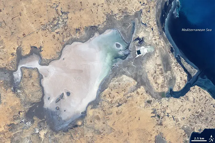
Sebkhat (or Sebkha) El Melah, Tunisia in 2001, mostly dry. Note rectangular industrial evaporite pans, probably for sea-salt production, upper right. Landsat 7 image.
In recent news, researchers are using GIS and remote sensing technology to examine the Sabkhas and tidal inlets in Al Batinah plain.
Sabkha is a transliteration of the Arabic word for a salt flat. Sabkhas are supratidal, forming along arid coastlines and are characterized by evaporite-carbonate deposits with some siliciclastics. Sabkhas form subaerial, prograding and shallowing-upward sequences that have an average thickness of a meter or less. The accepted type locality is along the coast of the Persian Gulf in the United Arab Emirates.
Dr. Yousef Shawky, the researcher at the College of Arts and Social Sciences, defines Sabkhas as divided into internal Sabkhas found usually in closed basins and coastal Sabkhas normally formed by ebb and tide mostly along coastal inlets. These forms have a direct effect on the development in Al Batinah plain in which population, settlement, and development in Oman are concentrated.
It is important and necessary to start and focus on studying Sabkhas and tidal inlets in Oman, especially in light of the emerging sea level changes. GIS and remote sensing technology could be very useful to monitor and determine any changes in the coast line and Sabkhas areas, supplemented by mechanical, chemical, mineral analysis to determine the deposition conditions in the endangered areas, simulate these changes and produce perspective maps for them.
Read original story at Oman Observer
Other Reference: Wikipedia