In a recent research by the UK Centre for Polar Observation and Modelling (CPOM) at the University of Leeds has produced the first complete map of how the ice sheet’s submarine edge, or “grounding line”, is shifting.
Most Antarctic glaciers flow straight into the ocean in deep submarine troughs, the grounding line is the place where their base leaves the sea floor and begins to float.
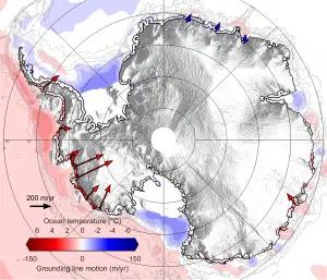
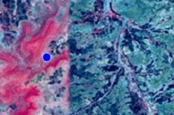
Grounding line map
Caption: Map showing rates of grounding line migration and their coincidence with ocean conditions around Antarctica between 2010 and 2016 (seabed temperatures: Locarnini et al., 2013. World Ocean Atlas 2013, Volume 1: Temperature. S. Levitus, Ed., A. Mishonov Technical Ed.; NOAA Atlas NESDIS 73, 40 pp.). Grounding line locations are from Rignot et al., 2013, Science 341 (6143), pp. 266-270.
Credit: Hannes Konrad et al, University of Leeds
The team, led by Dr Hannes Konrad from the University of Leeds, found that grounding line retreat has been extreme at eight of the ice sheet’s 65 biggest glaciers. The pace of deglaciation since the last ice age is roughly 25 metres per year. The retreat of the grounding line at these glaciers is more than five times that rate. This retreat has had a huge impact on inland glaciers, because releasing them from the sea bed removes friction, causing them to speed up and contribute to global sea level rise.
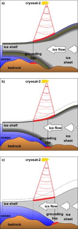
Grounding lines typically lie a kilometre or more below sea level and are inaccessible even to submersibles, so remote sensing methods for detecting them are extremely valuable.
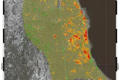
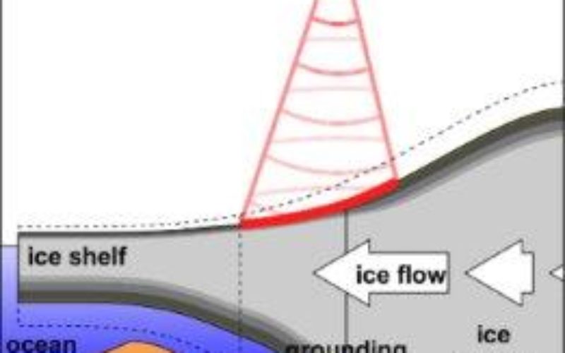
Grounding line illustration
Caption: Cartoon illustrating how horizontal motion of glacier grounding lines is detected using satellite measurements of their elevation change.
Credit: Hannes Konrad et al, University of Leeds
The team has used European Space Agency’s CryoSat-2 across 16,000 km of the coastline. Although CryoSat-2 is designed to measure changes in the ice sheet elevation, these can be translated into horizontal motion at the grounding line using knowledge of the glacier and sea floor geometry and the Archimedes principle of buoyancy – which relates the thickness of floating ice to the height of its surface.
Study co-author Professor Andy Shepherd, from the School of Earth and Environment at Leeds, said: “We were delighted at how well CryoSat-2 is able to detect the motion of Antarctica’s grounding lines. They are impossible places to access from below, and usually invisible on the ground, so it’s a fantastic illustration of the value of satellite measurements for identifying and understanding environmental change.”
Source: Eureka Alert