PlanetObserver Announces Release of PlanetSAT Global Imagery Basemap Version #2018
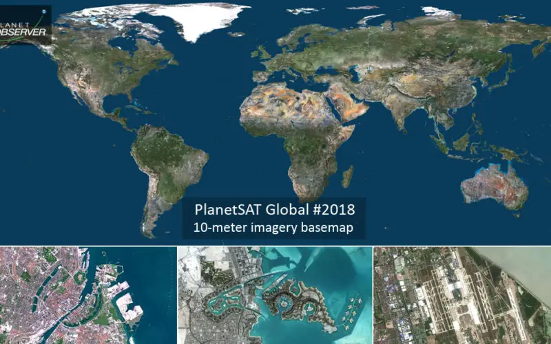
Clermont-Ferrand, France – 27 March 2018 – PlanetObserver, provider of geospatial data for civil and military solutions, announces the release of the most up-to-date global mosaic processed with recent and cloud-free satellite imagery.
With an unmatched 10-meter resolution at the global scale, PlanetSAT Global #2018 mosaic provides accurate geographic information for any part of the world. Users benefit from a seamless view of the Earth in high quality natural colors, for an enhanced visual experience!

PlanetObserver has selected best available multi-source data to process version #2018 of PlanetSAT Global mosaic. Very recent Sentinel-2 imagery at 10 meter resolution is used to update all largest urban areas across the world and all capital cities. Continents are updated with new Landsat 8 imagery. All our imagery is color-corrected, optimized and ready-to-use in different professional formats.
PlanetSAT Global #2018 mosaic will continue to bring great value to our users across different industries. The mosaic is easy to use in many military, commercial and consumer applications for visualization and simulation solutions, aircraft simulators, geo-intelligence solutions, web-mapping apps, to broadcast and weather graphics systems.
“With PlanetSAT Global Version #2018, we offer a completely improved product with higher spatial resolution and more recent imagery. On top of that, users save time with ready-to-use imagery, easy to implement in their solutions”, said Laurent Masselot, CEO of PlanetObserver
To find out more about PlanetSAT Global imagery basemap, visit PlanetObserver website at www.planetobserver.com.
About PlanetObserver
PlanetObserver offers a full range of value-added geospatial products: PlanetSAT range of global imagery basemaps, PlanetDEM global and accurate Digital Elevation Models, and on-demand service for Very High Resolution imagery and orthophotography. All products are developed internally, backed up by PlanetObserver’s know-how in geospatial data processing and more than 30 years of technological expertise.
PlanetObserver geospatial data are perfect for numerous commercial, military and consumer applications, ranging from web-mapping to 2D and 3D visualization and simulation solutions, GIS tools, cartographic mapping to audio-visual production.
Contact : PlanetObserver – 25 bd Gergovia – 63000 Clermont-Ferrand – France
Phone : (+33) 04 73 44 19 00 – info@planetobserver.com – www.planetobserver.com