
Ordnance Survey Maps Undergo Their Greatest Innovation For Over 200 Years

 Over the next 12 months Ordnance Survey is to replace all 607 of its current paper map titles (OS Explorer, OS Landranger and OS Tour series) with a new design and an additional mobile download of the map that can be accessed for no extra cost. Starting from 10 June when the OS Explorer Outdoor Leisure (OL) paper maps begin hitting retailers’ shelves.
Download hi-res versions of the covers below
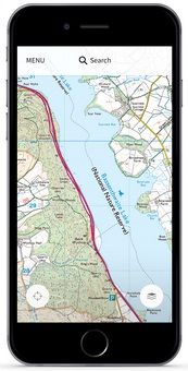
The Outdoor Leisure maps, which cover all of Britain’s national parks and areas of outstanding natural beauty, will come with an iOS and Android compatible download of the area covered by the map. The downloaded map will allow users to plot and store routes electronically. All the map data is stored locally and is available regardless of whether your smart device has a signal or not, making it perfect for even the remotest areas. Another standout feature is its ability to record your walk or cycle in real-time when out and about, so the route is instantly remembered for future exploration.
This news follows last year’s announcement that sales of OS paper maps had increased for the first time in a decade.
Nick Giles, Managing Director of Ordnance Survey Leisure, says: “Maps are the guide to the outdoors, the ideal tool for adventure and discovery. Feedback from customers showed that more and more people are using maps on their tablets and smartphones to navigate, despite some of these digital maps being less than ideal for finding paths and tracks in the countryside. OS maps give an unparalleled level of detail and are the definitive guide for any budding or seasoned explorer. For safety reasons we always recommend anyone exploring the outdoors carries a paper map, so it made absolute sense for us to combine both paper and digital formats, to give people what they want with the security of having paper, and the added functions our digital map offers should open up greater possibilities for further adventure.”
The much-loved paper maps will also have new covers. Photographs of Great Britain taken by members of the public in a competition run by OS, which received over 10,000 entries, will adorn the cover.
Nick continues: “The OS Photofit competition has exceeded expectations. We had way more entries than we anticipated and the overall standard was very impressive. There are a lot of talented amateur photographers out there. It proved very difficult for us to choose the winning images for our covers, but we did and we think they add to OS’s tradition of producing highly detailed accurate maps that also look like works of art.”
The OS Photofit is still open for OS Landranger series and closes 31 October.
Hi-res image downloads
Map covers
Map extracts on phones


