Developed for Forest Carbon Monitoring to Support Reducing Emissions from Deforestation and Forest Degradation (REDD+) in Kalimantan, Indonesia; Now Available for Public Use.
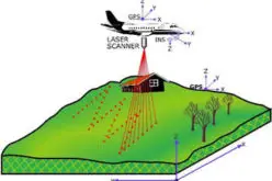
 For this project, Applied GeoSolutions and the University of New Hampshire have developed an Open Source Software package to process large amounts LiDAR data quickly, easily, and accurately. The Open Source project is called lidar2dems and includes the classification of raw LAS point clouds and the creation of Digital Terrain Models (DTMs), Digital Surface Models (DSMs), and Canopy Height Models (CHMs). Comprehensive, well documented, freely available software for processing LiDAR data can enable countries such as Indonesia to cost effectively monitor their forests with high precision.
Around the world, governments are establishing national forest monitoring systems (NFMS) that use a combination of remote sensing and ground-based forest carbon inventory approaches to estimate anthropogenic forest-related greenhouse gas emissions and removals. The NFMS forms the link between historical assessments and current/future assessments of forests, enabling consistency in the data and information to support the implementation of REDD+ activities. The creation of a reliable, transparent, and comprehensive NFMS is currently limited by a lack of relevant data that are accurate, low-cost, and spatially resolved at subnational scales.
In this NASA Carbon Monitoring System project, Applied GeoSolutions, with scientists at NASA Jet Propulsion Laboratory, Winrock International, and the University of New Hampshire, is developing, evaluating, and validating several critical components of a NFMS in Kalimantan, Indonesia, focusing on the use of LiDAR and radar imagery for improved carbon stock and forest degradation information.
Software and more information available at http://applied-geosolutions.github.io/lidar2dems/