NOAA Releases First GOES-16 Image from Harris Corporation-Built Imager and Ground System
- Imager and ground system increase resolution and speed
- Ground system will process more data than all current GOES satellites combined
- Advancements will improve weather forecasting for U.S. government
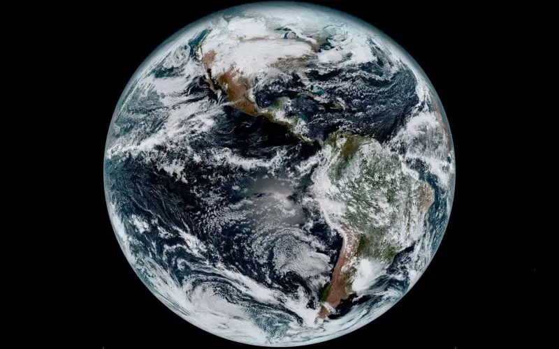
MELBOURNE, Fla. – January 23, 2017 – The National Oceanic and Atmospheric Administration (NOAA) has released the first image taken by Harris Corporation’s (NYSE:HRS) Advanced Baseline Imager (ABI) onboard their next-generation weather satellite. The image taken from the Geostationary Operational Environmental Satellite-16 (GOES-16) is of Earth’s full western hemisphere with detailed cloud and water features.
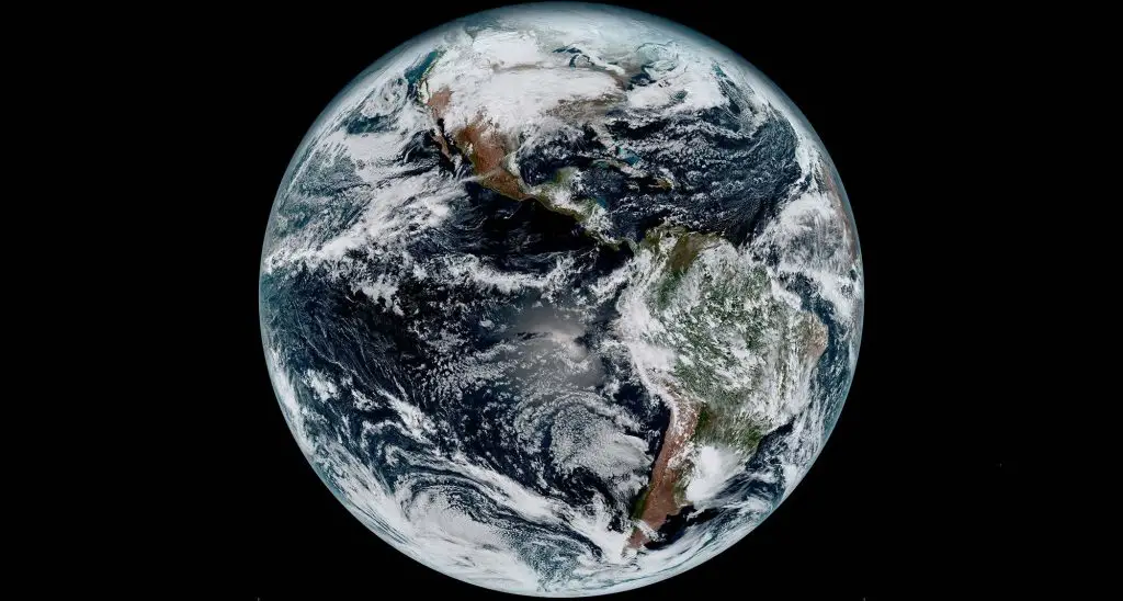
First GOES-16 Image
Credit: Harris Corporation
The Harris ABI, the main payload on the satellite, is a high-resolution digital camera with image resolution of one-tenth of a square mile, or four times better than current imagers. Additional filters, or spectral bands, on ABI will detect more information about volcanic ash, dust, clouds, winds, fires, rainfall rate, and hurricane intensity than previous generations of geostationary weather satellites. Critical information about severe weather events can come as fast as 30 seconds, five times faster than previous technology.
“Once the satellite is fully operational, the resolution of the imagery taken from the Harris ABI will be comparable to seeing a quarter from a mile away,” said Eric Webster, vice president and general manager, Harris Environmental Solutions.
The image was downloaded and processed by the Harris-built enterprise ground system, which controls the weather satellite and all of its six major instruments, including ABI. The ground system will also process the significant increase in new data, producing 1.75 terabytes of data per day for the National Weather Service and other users. In only three-and-a-half years, ABI data production will equal the total data production from 1975 through 2015 of all prior GOES imager and sounder data combined.
The GOES-16 was called GOES-R prior to its launch from Cape Canaveral, Fla., Nov. 19, 2016. Like its predecessors, GOES-R was renamed GOES-16 after launch, following NOAA’s numerical naming convention.
About Harris Corporation
Harris Corporation is a leading technology innovator, solving customers’ toughest mission-critical challenges by providing solutions that connect, inform and protect. Harris supports customers in more than 100 countries and has approximately $7.5 billion in annual revenue and 21,000 employees worldwide. The company is organized into four business segments: Communication Systems, Space and Intelligence Systems, Electronic Systems and Critical Networks. Learn more at harris.com.
<