New Suite of Products Available For SRAL Instrument on the Copernicus Sentinel-3a Satellite
The Synthetic Aperture Radar Altimeter (SRAL) instrument on board Sentinel-3A delivers accurate measurements of sea surface height, significant wave height and surface wind speeds over the world’s oceans for Copernicus ocean forecasting systems and for monitoring sea level change.
THURSDAY, 19 JANUARY 2017 – The instrument has been delivering operational data since 13 December 2016, with two different timestamps: Near real time (NRT) data are provided in less than 3 hours after data acquisition. Short Time Critical (STC) data reach the user within 48 hours after data acquisition. This data provides vital input for meteorological institutes and ocean modellers for the prediction of ocean currents, significant wave height and wind speed.
EUMETSAT has now started to release Non-Time Critical (NTC) data. These products are available within one month after data acquisition with the consolidation of various auxiliary and ancillary data that feed into the processing of the altimeter data, such as precise orbit information, platform attitude, and wet and dry tropospheric corrections. This new information will allow experts to conduct many geophysical studies, such as on ocean tides, mean sea level, sea level change, and ocean modelling.
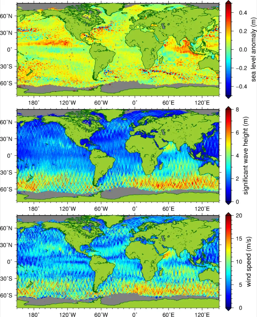
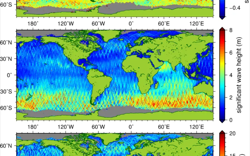
Figure 1. Measurements of sea level anomaly (top), significant wave height (middle), and wind speed (bottom) provided by EUMETSAT. This data was collected over a full repeat cycle of 27 days, from 28 June to 25 July 2016.
The precision of the NTC products is much increased compared to the STC products. This is due to an improved orbit determination – more information about the varying gravity field and rotation of the Earth is available when some time has passed between measurement and data delivery. Also, further adjustments caused by drifts compared to the measurement systems can be made. Due to these measures, the accuracy of the retrieval of sea level improves from approximately 5 cm to approximately 3 cm for the measurements taken every second. This allows for even precise studies and monitoring of our oceans.
This release also includes the Level 1B data – the profiles of the returned radar echoes. Users can apply their own algorithms to these data to even better retrieve sea level information under more complicated conditions, such as near coasts or in the presence of sea ice.

Figure 2. Altimeter waveforms of Sentinel-3A for a pass over the Arctic. The different response to sea ice, land, and open ocean can be seen.
For details on how to access these data, see here.
All data from the Sentinel-3 mission are cross-calibrated against the Jason-3 reference mission.
Additional Product Release
In addition to the Level 2 and Level 1B products, a new type of Corrected Sea Surface Heights products (also known as Level 2P products) have been released for Sentinel-3A. These products are global 1 Hz along-track data (sea level anomaly, its components and validity flag) over water.
They are based on marine Level 2 products with either Near Real Time, Short Time Critical or Non Time Critical timestamps. The new Level 2P products are distributed in the user-friendly NetCDF format and are available less than an hour later than the corresponding Level 2 products.
The Level 2P products are processed by the Sentinel-3 Level 2P/L3 Marine Altimetry Service (CNES/CLS), in the frame of a EUMETSAT contract, funded by the European Union.
The products are disseminated by AVISO+ (via authenticated ftp or AVISO+ CNES Data Center).
They will also be disseminated by EUMETSAT shortly (via EUMETCast, EUMETSAT Data Centre and potentially via CODA).
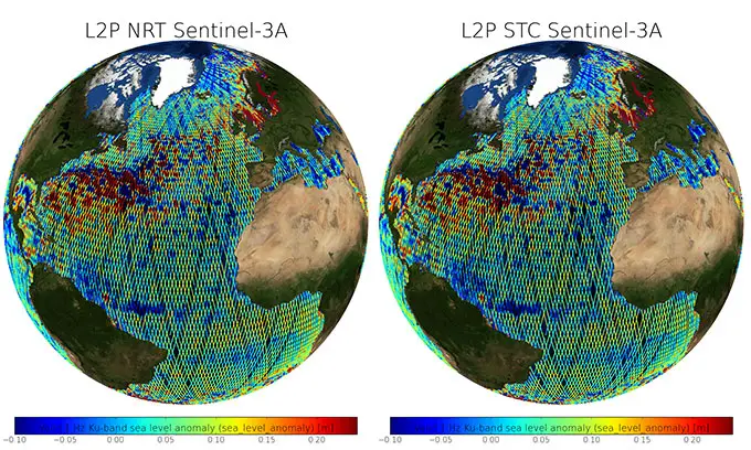
Figure 3: Sea level anomalies (m) from Sentinel-3A L2P NRT(left) and STC (right) products (cycle 12 pass 411 (22-12-2016 06:38:56) to cycle 13 pass 354 (16-01-2017 07:21:38)) after removing spurious measurements.
About Sentinel – 3A
Carrying a suite of instruments, Sentinel-3A has been designed to measure Earth’s oceans, land, ice and atmosphere to monitor large-scale global dynamics and to provide critical near-real-time information for many ocean, land and weather applications.
While the operations of the Sentinel-3A satellite are carried out by EUMETSAT, the mission is managed jointly by ESA and EUMETSAT.
ESA is responsible for the land data products and EUMETSAT for the marine products – all of which are made available for application through Copernicus services.
Source: EUMETSAT