NASA ARSET Training: Using NASA Remote Sensing for Disaster Management

NASA ARSET Training: Using NASA Remote Sensing for Disaster Management
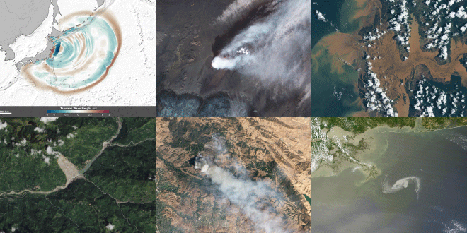
NASA remote sensing and modeling resources are useful for managing a variety of disasters – including earthquakes, tsunamis, volcanoes, floods, landslides, wildfires, and oil spills – particularly in regions with very little in situ data. This introductory webinar will provide an overview of NASA remote sensing data and applications for disaster management.
Course Format
- Four, 1 hour sessions, each held twice a day to allow for national and international participation in different time zones:
- Session A: 11:00 a.m. – 12:00 p.m. EDT (UTC-4)
- Session B: 6:00 – 7:00 p.m. EDT (UTC-4)
- Sessions will be held every Thursday: June 9, 16, 23, and 30
- A certificate of completion will be provided to participants that attend all four webinars and complete all homework – including the prerequisite assignment.
Learning Objective
Participants will become aware of available NASA resources for disaster management, and will learn to access remote sensing observations using covered web tools for local disaster events.
Prerequisites
- Fundamentals of Remote Sensing: Session 1
- Homework Assignment, due June 13
Intended Audience
National and international entities involved in disaster and water resources management, decision support activities, and relief and humanitarian activities.
Registration Information
This webinar is free, but you must register. Space is limited, and preference will be given to agencies listed above. Please only sign up for a single session – please check your local time to select your session preference. You will be notified by email if your registration has been approved on or before June 6, 2016.
- Register for Session A 11:00 a.m. – 12:00 p.m. EDT (UTC-4)
- Register for Session B 6:00 – 7:00 p.m. EDT (UTC-4)
Certificate
A certificate of completion will be provided to participants who attend all four webinars and complete all homework assignments by their due date.
Course Agenda
- Session 1 (June 9): Monitoring Earthquakes, Tsunamis, and Volcanoes Using NASA Remote Sensing
- Session 2 (June 16): Overview of Remote Sensing for Wildfire Applications
- Session 3 (June 23): Observing Oil Spills Using Remote Sensing Measurements
- Session 4 (June 30): Monitoring Storms, Floods, and Landslides Using Remote Sensing Observations
Register Now